Tropical Depression Henry Exits PAR; Potential Super Typhoon May Enter Next Week
Tropical Depression Henry has exited the Philippine Area of Responsibility (PAR), leaving no direct impact. However, a new weather disturbance is forecast to enter next week and could intensify into a super typhoon, prompting warnings from the state weather bureau.
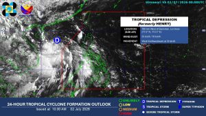
Tropical Depression Henry, which brought heavy rainfall and gale-force winds to several areas, has exited the Philippine Area of Responsibility (PAR), according to the state weather bureau on Thursday. It also said a potential super typhoon may enter the PAR next week. Henry exited the PAR around 8 p.m. on Wednesday and is no longer directly affecting any part of the country, the Philippine Atmospheric, Geophysical and Astronomical Services Administration (PAGASA) said during its 5 a.m. press briefing. As of 8 a.m., Henry was located 760 kilometers west of Bacnotan, La Union, packing maximum sustained winds of 55 kilometers per hour (kph) and gusts of up to 70 kph. After developing into a tropical cyclone on Wednesday morning, Henry prompted the hoisting of Tropical Cyclone Wind Signal No. 1 and heavy rainfall warnings in several areas of Luzon. PAGASA said Henry is expected to continue moving farther away from the country’s landmass. Meanwhile, a new weather disturbance may enter the PAR between July 6 and July 12 and could intensify into a super typhoon, PAGASA said. “So, it’s possible that by Wednesday or Thursday (next week), it may enter the PAR based on our latest data,” PAGASA weather specialist Leanne Loreto said during the press briefing in mixed English and Filipino. “We are seeing that it may intensify into typhoon or super typhoon,” she added. If it enters the PAR, it will be assigned the local name Inday, the country’s ninth tropical cyclone this year. PAGASA said the potential Inday had already intensified into a tropical storm while still outside the country’s monitoring domain. As for its forecast track, the system is projected to veer toward the North Philippine Sea, although PAGASA said its trajectory remains highly uncertain. The weather disturbance is also expected to enhance the southwest monsoon, bringing rains over the western sections of the country. “Therefore, we can expect rainfall over the western parts of the country from the middle of next week through the weekend,” Ms. Loreto said. She also urged residents in the western parts of the country to prepare for the possible effects of the potential super typhoon, should it enter the PAR. — Edg Adrian A. Eva
多角的分析
熱帯低気圧の接近は、農業や漁業に直接的な打撃を与える可能性がある。特に、収穫期に近い農作物や、漁船の出航停止は、食料供給と価格に影響を及ぼす。また、インフラへの被害が発生した場合、復旧には多額の費用と時間を要し、経済活動の停滞を招く。過去の台風被害では、GDP成長率の低下やインフレ率の上昇が記録されており、今回も同様のリスクが懸念される。
短期的な投資家にとっては、インフラ関連企業や保険会社への影響が注視される。一方で、災害復旧や生活必需品の需要増を見込み、関連企業の株価が一時的に上昇する可能性もある。しかし、スーパー台風の進路によっては、サプライチェーンの混乱や生産活動の停止が広範囲に及び、全体的な市場センチメントを悪化させるリスクも否定できない。長期投資においては、気候変動への適応策を進める企業の選別が重要となる。
フィリピンは熱帯低気圧の通り道にあり、国民は常に自然災害のリスクに晒されている。特に、低所得者層や沿岸部に居住する人々は、家屋の損壊や避難生活を余儀なくされる可能性が高い。公衆衛生への影響、特に避難所での感染症の蔓延も懸念される。政府による迅速かつ効果的な避難勧告や支援体制の整備が、被害の軽減に不可欠となる。
フィリピン国民、特に西部地域に住む人々は、来週の気象状況に大きな不安を抱いている。過去の経験から、熱帯低気圧や台風は家屋の損壊、停電、交通網の麻痺を引き起こし、日常生活に深刻な影響を与えることを知っている。スーパー台風となれば、その被害は甚大になるため、食料や水の備蓄、避難場所の確認など、個人レベルでの準備が急務となる。政府からの正確な情報提供と、迅速な避難支援が求められている。
背景・歴史的文脈
フィリピンは太平洋の「火山の輪」に位置し、地震や火山活動のリスクが高い地域であると同時に、太平洋の西部に位置するため、数多くの熱帯低気圧や台風が通過する「台風銀座」としても知られています。特に、フィリピン海域で発達した熱帯低気圧が、しばしば甚大な被害をもたらしてきました。過去には、2013年のスーパー台風「ヨランダ」(ハイエン)が、甚大な被害と多数の死者を出した例があります。PAGASAは、これらの気象現象を監視し、国民に警報を発令する重要な役割を担っています。近年、気候変動の影響により、台風の勢力が増大する傾向も指摘されており、フィリピンにおける防災対策は喫緊の課題となっています。
原文ソース
BusinessWorld Nation