General articles are free for 24 hours after publish.
Low pressure area near Myanmar coast develops into a strong tropical storm, may cross into India: Met Department
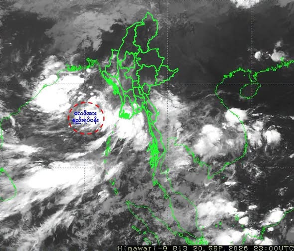
The low-pressure area near Myanmar's coast is forecast to develop into a strong tropical storm within the next 36 hours and may cross into India, according to the Meteorological Department. Due to the influence of this l
The low-pressure area near Myanmar's coast is forecast to develop into a strong tropical storm within the next 36 hours and may cross into India, according to the Meteorological Department. Due to the influence of this low-pressure area, heavy rainfall is possible in some areas of Yangon, Mandalay, Bago, Magway, Sittoung, Ayeyarwady, Tanintharyi, Karen, Mon, and Rakhine states and regions between September 21 and 25. According to observations on the morning of September 21, the low-pressure area (Low Pressure Area) that formed in the central Bay of Bengal and the northern part of the adjacent Andaman Sea (near Myanmar's coast) has reached the central Bay of Bengal (near Myanmar's coast). This low-pressure area may move west-northwest and is expected to intensify into a depression (Depression) in the central Bay of Bengal within the next 18 hours, and into a deep depression (Deep Depression) in the western Bay of Bengal within the next 36 hours. It may continue to move west-northwest and reach the western Bay of Bengal and the adjacent northwestern Bay of Bengal (southern Odisha - northern Andhra Pradesh coast of India) within the next 72 hours, according to forecasts. Due to the influence of the low-pressure area, scattered thunderstorms are expected in the upper Sagaing region, Kachin State, and Shan State (North and East), and widespread thunderstorms are expected in Nay Pyi Taw, Yangon Region, Mandalay Region, Bago Region, Magway Region, lower Sagaing Region, Ayeyarwady Region, Tanintharyi Region, Kayah State, Karen State, Chin State, Mon State, Rakhine State, and southern Shan State. Heavy rainfall is possible in localized areas of Yangon Region, Mandalay Region, Bago Region, Magway Region, lower Sagaing Region, Ayeyarwady Region, Tanintharyi Region, Karen State, Mon State, and Rakhine State. Along the Myanmar coast and in the offshore waters, squalls with strong winds are expected to occur intermittently, causing rough seas. During squalls, the wind speed over the sea and land may reach up to 35 miles per hour, and wave heights along the Myanmar coast and in offshore waters may be around 9 to 12 feet. Therefore, due to the influence of the low-pressure area, natural disasters such as heavy rainfall, strong winds, sudden floods, and landslides may occur. Residents living near elevated areas are advised to be aware of the risk of landslides, and those living near small rivers and streams are advised to be aware of floods and overflows. The Meteorological Department also advises domestic flights, and coastal and offshore fishing vessels and ships along the Myanmar coast and in offshore waters to take precautions and avoid the affected areas in advance.
Original source
Eleven Media