Chiang Rai on High Alert for Flooding Amid Predicted Heavy Rains
Chiang Rai province in northern Thailand is facing flash flood risks in several communities due to heavy downpours. Military and local officials are working to reinforce flood defenses, including sandbag walls along the Sai River, as further heavy rain is predicted.
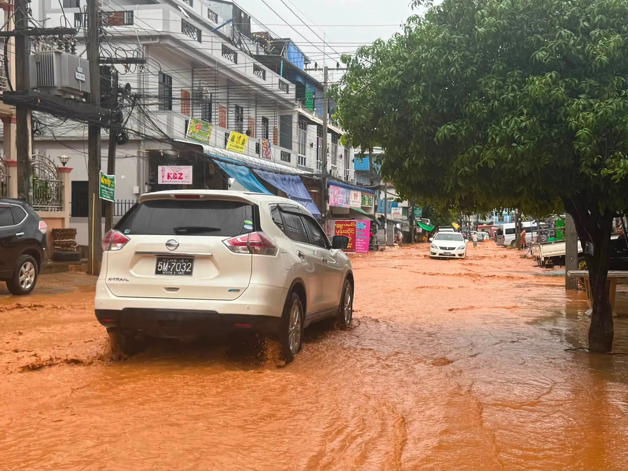
CHIANG RAI – Military personnel and local officials in Mae Sai, Chiang Rai, are working around the clock to secure flood defenses. Heavy downpours hit Chiang Rai province hard, leaving several communities vulnerable to flash floods. The immediate flash flood crisis has recently started to improve in many areas. However, weather monitors warn that more storms are actively moving toward the northern border region. The early warning system in Wiang Phang Kham sub-district triggered an alert after massive rainfall. Local officials reported that the storm dropped 102.0 millimeters of water overnight. This sudden downpour sent mud and debris sliding down mountains, blocking key routes between Chiang Khong and Chiang Saen. Emergency teams quickly cleared the blocked roads, which allowed light vehicles to pass through safely again. The continuous rain means the soil remains unstable, forcing road crews to monitor the mountain passes closely. According to updates from the Thairath news agency, the Third Development Division joined forces with the 37th Military District. Together with local administrative teams, they built a long wall of heavy sandbags along the Sai River. These barriers stretch from the Tham Pha Chom village down to the second Thai-Myanmar Friendship Bridge. Residents stated that the taller walls give them peace of mind against sudden river overflows. Even though the situation looks stable, families in low-lying villages are actively moving their belongings to higher floors. The heavy currents also caused structural damage deeper inside the province. In the Tab Tao sub-district, rushing waters severely eroded the foundations of the Ban Pang Kha bridge. Transport officials have already deployed engineering teams to repair the bridge and restore local travel routes quickly. Weather experts from the Hydrogeology Department warn that the danger has not passed yet. The latest weather radar images show dense rain clouds covering most parts of northern Chiang Rai. Officials advise residents living near mountain slopes and waterways to keep emergency bags packed and follow daily weather announcements.
多角的分析
チェンライ県はタイ有数の農業地域であり、今回の豪雨によるインフラ被害や農作物への影響は、地域経済に打撃を与える可能性があります。特に、道路の寸断は物流を滞らせ、農産物の市場への出荷を困難にするため、農家の収入減に直結します。また、橋梁の損壊は、地域間の経済活動を阻害し、復旧には相当なコストと時間を要すると考えられます。
短期的な投資家にとっては、インフラ復旧関連の建設資材やサービスへの需要増加が期待される一方、長期的な視点では、気候変動による災害リスクの増大が、チェンライ地域への投資判断に影響を与える可能性があります。特に、観光業や農業関連への投資は、自然災害への脆弱性を考慮する必要があるでしょう。
洪水による住民の生活への直接的な影響は甚大です。家財道具の移動や避難生活は、精神的な負担も大きく、特に低所得者層や高齢者にとっては、経済的・身体的な困難を増大させます。また、道路の寸断は、医療や教育へのアクセスを妨げる可能性もあり、地域社会の分断を招く恐れもあります。
タイ北部の住民、特にチェンライ県に住む人々は、季節的な雨季に加えて、近年増加傾向にある異常気象による洪水の脅威に常に晒されています。今回の事例は、住民が日常的に直面する自然災害のリスクを浮き彫りにし、避難計画や防災意識の重要性を再認識させるものとなっています。特に、インフラの脆弱性は、住民の安全と生活基盤を脅かす要因となっています。
背景・歴史的文脈
タイ北部、特にチェンライ県は、メコン川流域に位置し、雨季にはしばしば洪水に見舞われる地域です。過去にも、2011年の大洪水や、近年の局地的な豪雨による土砂災害などが報告されています。これらの災害は、急速な都市化や森林伐採による土地利用の変化、そして地球温暖化による気象パターンの変動が複合的に影響していると考えられています。今回の事例は、こうした構造的な脆弱性が、気候変動の影響と相まって、より深刻な被害をもたらす可能性を示唆しています。
原文ソース
Chiang Rai Times