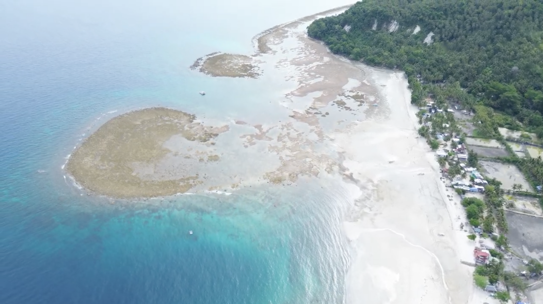
Phivolcs Recommends No-Build Zones for Coastal Uplift Areas in Philippines
The Philippine Institute of Volcanology and Seismology (Phivolcs) recommends designating coastal uplift areas, formed after a Magnitude 7.8 earthquake, as "no-build zones" due to their instability and high risk of tsunamis and seismic events. These areas should be restricted to research and educational purposes.
The Philippine Institute of Volcanology and Seismology (Phivolcs) is recommending that areas experiencing coastal uplifts, which occurred following a Magnitude 7.8 earthquake, be classified as "no-build zones" due to their inherent instability and heightened risk from tsunamis and seismic events. These areas, it is suggested, should be restricted to research and educational purposes. Edward Louise E. Orquillas, Science Research Assistant and member of Phivolcs XI's Project Management and Core Capability Enhancement Team, stated that coastal uplifts are by default unstable ground and are therefore unsuitable for housing. He explained that these areas are also prone to future seismological events, as well as hazardous tsunamis, since they face the sea. "Hindi siya applicable for pabahay, kasi pwede siyang maging tatamaan ng mas further earthquake events or storm surge" (the uplifts are not suitable for housing, because these are vulnerable to further earthquake events or storm surges), Orquillas said. Coastal uplift is a geological phenomenon where portions of the seafloor rise, exposing what were once submerged coral reefs and marine habitats, leading to the alteration of a coastline. The uplifts in various parts of the Soccsksargen and Davao regions occurred due to the June 8 Magnitude 7.8 earthquake. He suggested that these sites could instead be recommended for research and educational purposes. "Pwede siguro gawin for research purposes pero hindi na siya pwede for land use or structural or agricultural or kahit na ano, except yan lang sa research for protected area," Orquillas added. On June 17, the Department of Environment and Natural Resources (DENR) had also warned against building any infrastructure, including houses, on the coastal uplift sites. PNA quoted Karlo Queaño, DENR-Mines and Geosciences Bureau (MGB) Assistant Secretary, as telling Radyo Pilipinas that it is dangerous to live in coastal uplift areas. "Kaya po rito sa Mindanao, importante na, although uplifted, kailangan po nating maintindihan kung ang dagat po eventually ay bumabalik din po. Kaya sa ganitong sitwasyon, we really discourage na ito ay tayuan at mas maganda nga po gawing siyang geologic monument" (So here in Mindanao, it is important that although uplifted, we need to understand if the sea will eventually return. So in this situation, we really discourage building on it, and it would be better to make it a geologic monument), Queaño said. Phivolcs conducted rapid assessments from June 9 to 19 across five provinces, two cities, 21 municipalities, and 110 affected barangays. The team identified 42 coastal uplifts, 52 tsunamis, 127 instances of liquefaction, and damage to 471 structures. The assessment included aerial surveys, field investigations, geologic impacts and hazard assessments, structural damage and intensity surveys, and aftershock monitoring. Phivolcs also installed five temporary seismic stations to enhance continuous aftershock monitoring in Glan and Kiamba in Sarangani, Jose Abad Santos in Davao Occidental, Balut Island, Santo Niño in South Cotabato, and Senator Ninoy Aquino in Sultan Kudarat, according to the Philippine Information Office RXII. The monitoring team comprised geologists, engineers, and social scientists. In Barangay Balangonan, Jose Abad Santos, Davao Occidental, coral platforms approximately 50 meters wide were exposed after a coral bed was raised by as much as 2.5 meters, according to a June 19 post by the Phivolcs-DOST Facebook Page. The Balangonan shore is now located 200 meters farther from its previous position. (Yas D. Ocampo / MindaNews)
多角的分析
沿岸隆起地域を建築禁止区域とすることは、これらの地域に依存していた漁業や観光業に影響を与える可能性があります。しかし、長期的に見れば、災害リスクの高い地域への開発を抑制することで、復旧・復興にかかる莫大な経済的損失を防ぐことができます。また、これらの地域を研究・教育目的で活用することは、新たな産業や知識創出の機会につながる可能性も秘めています。フィリピン経済は自然災害の影響を受けやすいため、このような予防的措置は経済の安定化に寄与すると考えられます。
沿岸隆起地域への投資は、極めて高いリスクを伴います。PhivolcsおよびDENRからの明確な警告は、これらの地域での不動産開発やインフラ投資を躊躇させる要因となります。投資家は、より安全で安定した地域への投資を優先するでしょう。ただし、研究施設や環境保護関連のプロジェクトであれば、政府の支援や国際機関からの資金調達により、限定的な投資機会が存在する可能性はあります。リスク管理の観点からは、これらの地域への新規投資は避けるべきです。
沿岸隆起地域に住む住民は、生活基盤の喪失や移住を余儀なくされる可能性があります。特に、これらの地域で生計を立てていた漁業関係者や小規模事業者は、新たな収入源の確保や移住先での生活再建という困難に直面します。政府は、住民への適切な補償、移住支援、新たな雇用機会の提供など、包括的なセーフティネットを構築する必要があります。また、地域コミュニティの結束や伝統的な生活様式が失われることへの配慮も不可欠です。
今回のPhivolcsの提言は、沿岸地域に住む多くのフィリピン市民にとって、生活の安全を最優先するべきだというメッセージを強く伝えています。特に、過去の地震や津波の経験から、自然災害への不安を抱える人々にとって、建築禁止区域の設定は、将来的な被害を防ぐための当然の措置と受け止められるでしょう。しかし、移住を迫られる住民にとっては、生活再建への不安が募ることも予想されます。政府は、住民の安全確保と生活支援の両立を図る必要があります。
背景・歴史的文脈
フィリピンは環太平洋火山帯に位置し、地震や津波の頻発地域です。特に、2023年6月8日に発生したマグニチュード7.8の地震は、フィリピン南部の沿岸地域に甚大な被害をもたらしました。この地震により、海底の一部が隆起し、沿岸線が変化する「沿岸隆起」という現象が広範囲で観測されました。過去にも、1990年のルソン島地震や2013年のボホール地震など、フィリピンでは大規模な地震が発生し、地盤変動や液状化、津波による被害が報告されています。これらの経験から、フィリピン政府は災害リスク管理の重要性を認識し、建築基準の見直しやハザードマップの整備を進めてきましたが、今回の沿岸隆起は、新たな課題として浮上しています。
原文ソース
MindaNews Philippines (GN)