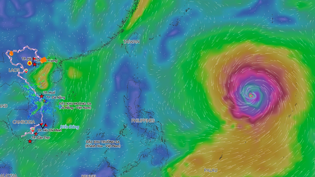
Super Typhoon Ba Vi Approaches, Threatening Strong Winds and High Waves in Vietnam's Eastern Seas
Environment
2026年7月7日
5
VnExpress
Relations
🇻🇳Vietnam🇨🇳China🇵🇭Philippines

Super Typhoon Ba Vi Approaches, Threatening Strong Winds and High Waves in Vietnam's Eastern Seas

AI サマリー

Super Typhoon Ba Vi has slightly weakened but its extensive reach is expected to bring strong winds and high waves across Vietnam's eastern seas starting this weekend. Fishermen are urged to exercise extreme caution.

The National Center for Hydro-Meteorological Forecasting reported that as of 7 AM on July 7, Super Typhoon Ba Vi's eye was located approximately 1,850 km east of the central Philippines and 2,100 km southeast of Taiwan. The typhoon maintained a wind speed of 201 km/h, a slight decrease from the previous day but still classifying it as a super typhoon. Over the next 24 hours, Ba Vi is expected to move westward at a speed of 25-30 km/h. Around July 9, its speed will decrease to 15-20 km/h, and it will shift its course to a west-northwest direction, heading towards Taiwan. The super typhoon intensity is projected to be maintained for another 2-3 days. By around July 10, the typhoon is forecast to begin weakening. On July 11, its center is expected to pass north of Taiwan before making landfall in China's Fujian province on July 12, and then further weaken inland. The Japan Meteorological Agency indicated that the typhoon's current wind speed is 180 km/h and could increase to 200 km/h by tomorrow. The Hong Kong Observatory estimates that the typhoon will maintain an intensity of 220 km/h for the next two days. International meteorological agencies generally agree that the typhoon will not enter the East Sea (South China Sea). While Vietnamese meteorological agencies assess the probability of Ba Vi directly entering the East Sea as very low, they warn that its extensive circulation could still impact weather conditions in the waters where Vietnamese fishermen operate. From July 9, the southwest monsoon is expected to strengthen in the southern East Sea, including the waters around the Truong Sa Archipelago (Spratly Islands), reaching level 6 winds (39-49 km/h). On July 10-11, winds in the northern, central, and southern East Sea, including the waters around the Hoang Sa Archipelago (Paracel Islands) and Truong Sa Archipelago, could reach levels 6-7 (39-61 km/h) with wave heights of 3-5 meters. Ship owners are advised to closely monitor the typhoon's developments and take appropriate measures for safety. The National Center for Hydro-Meteorological Forecasting stated that it continues to closely track the evolution of Super Typhoon Ba Vi to provide the latest forecasts. Ba Vi is the third super typhoon to form in the Western Pacific region in 2026. Previously, Typhoon Maysak made landfall in China's Guangxi Zhuang Autonomous Region after crossing the Gulf of Tonkin, subsequently weakening and dissipating inland. In Vietnam, Maysak primarily affected Mong Cai City and Co To Island in Quang Ninh province. The typhoon caused roof damage to 96 houses, damaged three cars, swept away or sank 13 boats and rafts, toppled 16 electricity poles, impacted approximately 1,100 hectares of aquaculture, 40 hectares of rice paddies, 5 hectares of industrial crops, and caused about 1,620 trees to break or fall. The total estimated material damage was VND 20 billion (approximately $800,000 USD). According to the National Center for Hydro-Meteorological Forecasting, July to September marks the peak of the 2026 typhoon season. The number of typhoons and tropical depressions in the East Sea is predicted to be close to the multi-year average, but the possibility of strong typhoons with complex trajectories significantly impacting Vietnam's mainland and waters remains. Source: VnExpress

多角的分析

経済的影響

台風バヴィの進路はベトナム本土への直接的な影響は小さいと予測されているものの、広範な影響圏による東シナ海(南シナ海)の海況悪化は、ベトナムの重要な漁業活動に直接的な打撃を与えうる。特に、チュオンサ諸島やホアンサ諸島周辺海域での高波・強風は、漁船の出漁を制限し、水産物供給の不安定化を招く可能性がある。これは、国内の食料供給だけでなく、輸出にも影響を与えかねない。過去の台風メイサークによる被害(約200億ドン)は、経済的損失の大きさを物語っており、今回も同様の被害が発生すれば、地域経済に一時的ながらも無視できない影響を及ぼすだろう。

投資家心理

今回の台風バヴィは、ベトナム本土への直接的な上陸リスクが低いとされているため、短期的な投資市場への影響は限定的と見られる。しかし、ベトナムの経済成長を支える輸出産業や、国民生活に不可欠な水産業への間接的な影響は考慮すべきである。特に、漁業関連企業や、水産加工品を扱う企業のサプライチェーンへの一時的な混乱は、短期的な株価変動要因となりうる。長期的な視点では、ベトナムのインフラ整備の遅れが、自然災害に対する脆弱性を高めている可能性も指摘されており、気候変動への適応策への投資が注目される。

社会的影響

台風バヴィの広範な影響圏は、ベトナムの沿岸地域、特に漁業に依存するコミュニティに不安をもたらしている。7月10日から11日にかけて予想される波高3~5mの荒波は、日々の生計を漁業に頼る多くの漁民とその家族の生活を直接脅かす。彼らは、安全な避難場所の確保や、漁船の保護といった具体的な対策を講じる必要に迫られる。また、過去の台風メイサークによる被害(家屋、船舶、インフラへの損害)は、災害に対する脆弱性を浮き彫りにしており、今回の台風がもたらす可能性のある被害への備えが、社会的な課題として改めて認識される。

市民の声

台風バヴィの進路は台湾や中国本土に向かっているものの、ベトナムの東シナ海(南シナ海)では風力6~7級、波高3~5mの荒波が予想されている。これは、沿岸部や島嶼部に住む市民、特に漁業で生計を立てている人々にとって、直接的な脅威となる。漁に出ることができなくなるだけでなく、住居や漁船の安全確保も懸念される。過去の台風メイサークで、家屋の損壊や船舶の被害が発生した事例もあり、市民は常に最新の気象情報を注視し、早めの避難や対策が求められる。特に、地方の漁村では、情報伝達の遅れや避難施設の不足が課題となる可能性がある。

背景・歴史的文脈

ベトナムは、南シナ海に面しており、台風の通り道となることが多い。特に7月から9月は台風シーズンであり、過去にも多くの被害が発生している。2026年の台風バヴィは、フィリピン沖で発生し、台湾・中国方面へ向かう進路をとっているが、その広範な影響圏はベトナムの漁業海域にも及ぶ。2020年に発生した台風メイサークは、ベトナム北部に上陸し、家屋やインフラに甚大な被害をもたらした。これらの経験から、ベトナム政府は常に台風の動向を監視し、国民への注意喚起と災害対策に努めている。ベトナムの一党体制下では、中央政府の指示のもと、迅速な情報伝達と避難指示が行われるが、地方や離島での対応には課題も残る。

原文ソース

VnExpress

原文を読む