General articles are free for 24 hours after publish.
Typhoon No. 5 Approaches Northeast South China Sea, Hazard Level 3 Issued
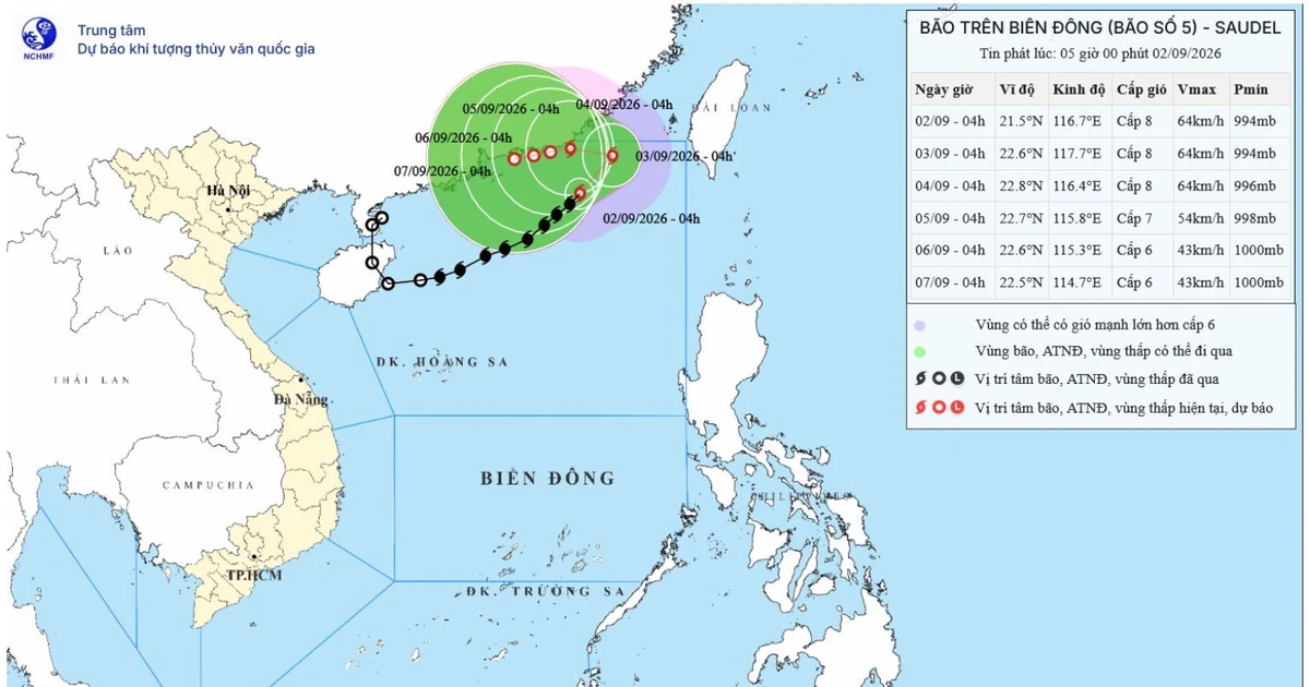
Typhoon No. 5 has formed in the northeast South China Sea off Vietnam's coast, with maximum sustained winds of Force 8 (62-74 km/h) and gusts up to Force 10. It is forecast to weaken into a tropical depression by September 5th, but ships are warned of high waves and strong winds.
Typhoon No. 5 has formed in the northeast South China Sea off Vietnam's coast, prompting a hazard level 3 alert. According to the National Center for Hydro-Meteorological Forecasting, as of 4 AM on September 2nd, the typhoon's center was located east of the northeastern South China Sea, at approximately 21.5 degrees North latitude and 116.7 degrees East longitude. Maximum sustained winds near the center are estimated at Force 8 (62-74 km/h), with gusts up to Force 10. The typhoon is moving northeast at about 15 km/h. By 4 AM on September 3rd, the typhoon is expected to continue moving northeast at 5-10 km/h, with maximum sustained winds near the center remaining at Force 8 and gusts up to Force 10. The affected area is the eastern part of the northeastern South China Sea, with a hazard level of 3. By 4 AM on September 4th, the typhoon will be moving west-northwest at approximately 5 km/h over the waters southeast of Guangdong Province, China. Maximum sustained winds near the center will be Force 8, with gusts up to Force 10. The affected area remains the eastern part of the northeastern South China Sea, with a hazard level of 3. By 4 AM on September 5th, the typhoon is forecast to move west-southwest at about 3 km/h over the waters southeast of Guangdong Province and weaken into a tropical depression. The affected area is the eastern part of the northeastern South China Sea, with a hazard level of 3. Over the next 72 to 120 hours, the tropical depression is expected to move west-southwest at approximately 3 km/h, gradually weakening. Due to the typhoon's influence, the eastern waters of the northeastern South China Sea will experience strong winds of Force 6-7, with gusts up to Force 8-9, and wave heights of 3-5 meters. Near the typhoon's center, winds will reach Force 8 with gusts up to Force 10, and wave heights will be 4-6 meters, indicating rough seas. Ships operating in these dangerous areas are at risk of encountering thunderstorms, tornadoes, strong winds, and large waves.
Original source
Nhan Dan