Tropical Depression Henry forms off Bataan, bringing rain to Metro Manila and surrounding areas
Tropical Depression Henry has formed off the coast of the Philippines, located west-southwest of Bataan and moving northwest. Rain and thunderstorms are expected in Metro Manila and surrounding areas, with wind signals issued for some regions.
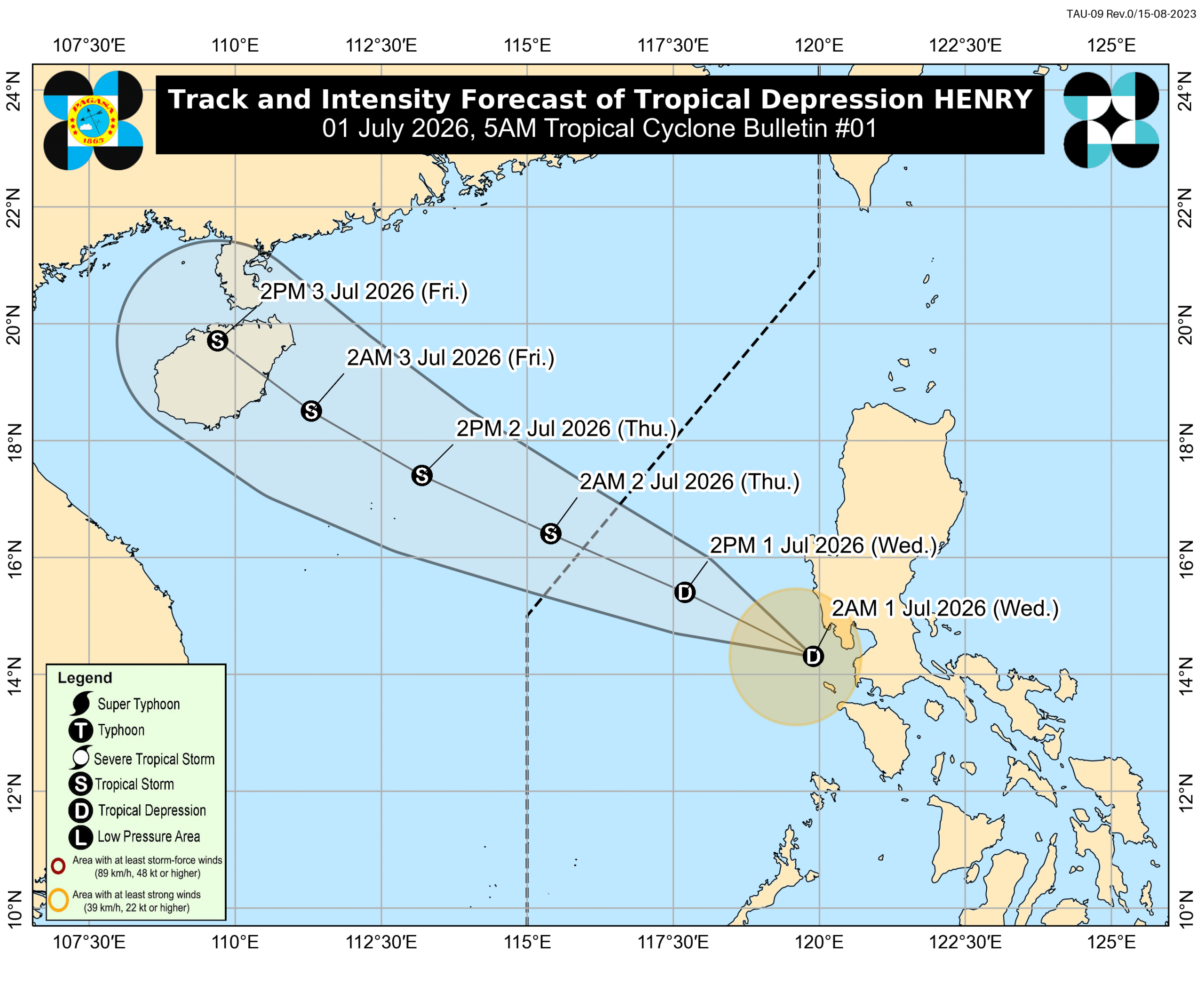
MANILA, Philippines – The low pressure area (LPA) inside the Philippine Area of Responsibility (PAR) developed into a tropical depression at 2 am on Wednesday, July 1. It was given the local name Henry, as the country’s eighth tropical cyclone for 2026. It is also the first tropical cyclone for July. The Philippine Atmospheric, Geophysical, and Astronomical Services Administration (PAGASA) said Henry was located 115 kilometers west southwest of Abucay, Bataan, as of 4 am on Wednesday. The tropical depression is moving northwest or away from landmass at 25 kilometers per hour (km/h). It already crossed land on Tuesday, June 30, as an LPA. So far, Henry has maximum sustained winds of 45 km/h and gustiness of up to 55 km/h. But PAGASA expects it to gradually intensify over the West Philippine Sea, and possibly strengthen into a tropical storm by Thursday morning, July 2 — also the time of its projected exit from PAR. On Wednesday, Henry is bringing rain to Metro Manila, Calabarzon, Zambales, Bataan, Bulacan, Tarlac, Pampanga, Occidental Mindoro, Oriental Mindoro, and Marinduque. The most affected provinces could be Occidental Mindoro and Oriental Mindoro, where moderate to heavy rain (50-100 millimeters) is expected. Henry is also enhancing the southwest monsoon or habagat, which is causing scattered rain and thunderstorms on Wednesday in the rest of Mimaropa, Western Visayas, the Negros Island Region, Central Visayas, the Zamboanga Peninsula, the Bangsamoro Autonomous Region in Muslim Mindanao, Lanao del Norte, Misamis Oriental, and Misamis Occidental. Palawan may be the most affected, with moderate to heavy rain (50-100 mm). For strong winds due to Henry, Signal No. 1 was raised in the following areas in Luzon at 5 am on Wednesday: southwestern part of Zambales (San Antonio, Castillejos, Subic, Olongapo City) western part of Bataan (Morong, Bagac, Mariveles) Lubang Islands PAGASA added that the periphery or outer bands of the tropical depression and the southwest monsoon are bringing strong to gale-force gusts to these areas: Wednesday, July 1 Batanes, Cagayan, Ilocos Norte, Pangasinan, Tarlac, Nueva Ecija, Pampanga, Bulacan, Metro Manila, Calabarzon, Occidental Mindoro, Palawan Thursday, July 2 Batanes, Cagayan, Pangasinan, Zambales, Bataan, Palawan Friday, July 3 Pangasinan, Zambales, Palawan In the next 24 hours, up to moderate seas are likely in these seaboards: Seaboards of Cagayan and Isabela; western seaboards of Zambales, Bataan, and Lubang Islands – waves up to 2.5 meters high Seaboards of Aurora and Batanes; northern seaboard of Ilocos Norte; western seaboards of La Union, Pangasinan, and Palawan – waves up to 2 meters high Small vessels should take precautionary measures, or avoid sailing, if possible. PAGASA’s latest estimates show nine to 13 tropical cyclones could form within or enter PAR from July to December 2026. Here is the breakdown per month: July – 2 to 4 August – 2 to 4 September – 2 or 3 October – 1 or 2 November – 1 or 2 December – 1 or 2 Formation inside or entry into PAR does not necessarily mean automatic impact on Philippine weather and sea conditions, as that would depend on multiple factors, including the location, track, and intensity of a tropical cyclone. – Rappler.com
多角的分析
熱帯低気圧「ヘンリー」の発生は、フィリピン経済に短期的な影響を与える可能性がある。特に、農作物への被害や、交通・物流の遅延が懸念される。PAGASAの予測によると、7月から12月にかけて複数の熱帯低気圧がフィリピン管轄海域(PAR)に進入または発生するとされており、これは年間を通じた経済活動、特に農業や漁業へのリスク要因となる。過去の事例では、台風によるインフラ被害の復旧や、サプライチェーンの寸断がGDP成長率に影響を与えたケースもある。
投資家にとって、熱帯低気圧の頻発はインフラ関連企業や保険会社へのリスク要因となる一方、復旧・再建関連への投資機会も生み出す可能性がある。特に、長期的な視点では、気候変動への適応策や強靭なインフラ整備への投資が重要視されるだろう。フィリピン証券取引所(PSE)の動向は、こうした自然災害リスクと政府の対応策によって左右される可能性がある。
熱帯低気圧「ヘンリー」の通過は、マニラ首都圏や沿岸部の住民の生活に直接的な影響を与える。特に、低所得者層や脆弱なコミュニティでは、家屋の損傷、避難生活、生計手段の喪失といったリスクが高まる。過去の台風被害では、避難所の衛生状態や食料供給、そして被災後の生活再建における支援の遅れが社会的な課題として浮上してきた。今回のヘンリーによる影響も、こうした既存の社会課題を露呈させる可能性がある。
マニラ首都圏の市民は、ヘンリーによる雨や強風の影響で、通勤・通学の混乱や、低地の浸水被害を懸念している。特に、公共交通機関の遅延や運行停止は、日々の生活に大きな影響を与える。また、食料品や生活必需品の価格変動も、家計を圧迫する要因となりうる。過去の台風被害の経験から、住民は早期の避難や備蓄の重要性を認識しているが、十分な備えができない層も少なくない。
背景・歴史的文脈
フィリピンは、太平洋「火山の輪」と「台風銀座」に位置するため、地震や火山噴火、そして年間約20個の台風に襲われる自然災害多発国である。特に、熱帯低気圧は、フィリピンの気象、経済、社会インフラに毎年深刻な影響を与えている。過去には、2013年の台風ハイエン(ヨランダ)が甚大な被害をもたらし、復興に長年を要した。PAGASAは、気候変動の影響により、今後、より強力な台風が発生する可能性を指摘しており、政府は防災・減災対策の強化を迫られている。今回のヘンリーは、その年の気象パターンの一部であり、今後の台風シーズンへの警戒を促すものと言える。
原文ソース
Rappler Philippines