General articles are free for 24 hours after publish.
Typhoon Saudel Regenerates, Becomes Fifth Storm of the Year in South China Sea
Typhoon Saudel has regenerated from a tropical depression in the northern South China Sea, becoming the fifth typhoon of the year. Authorities are urging caution as potential impacts on Vietnam's coast are a concern.
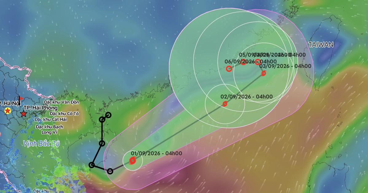
Early on September 1, a tropical depression (a weakened form of Typhoon Saudel) in the western part of the northern South China Sea strengthened again into a typhoon. This marks the fifth typhoon to form in the South China Sea this year. According to the National Center for Hydro-Meteorological Forecasting, as of 4 AM on September 1, the center of Typhoon No. 5 was located in the western waters of the northern South China Sea, about 240 km north of the Hoang Sa Archipelago (Paracel Islands). The strongest wind speed near the eye of the storm reached level 8 (62-74 km/h), with gusts up to level 10. The forecast indicates that Typhoon No. 5 will move northeastward towards the Taiwan Strait at a relatively fast speed of 15-25 km/h over the next one to two days, with little change in intensity expected. By 4 AM on September 3, the typhoon is projected to be in the northeastern waters of the northern South China Sea, maintaining its intensity at level 8 with gusts up to level 10. However, during the night of September 3, the typhoon's path may change, moving northwestward at a slower speed of 3-5 km/h, with a possibility of weakening into a tropical depression. By 4 AM on September 4, it is expected to be a tropical depression over the sea south of Fujian Province, China, with wind speeds of level 7 (50-61 km/h) and gusts up to level 9. Subsequently, the tropical depression is forecast to move westward and gradually weaken. Due to the influence of Typhoon No. 5, the northern South China Sea (including the Hoang Sa Archipelago) will experience strong winds of level 6-7, with gusts up to level 8-9, and wave heights of 2-4 meters. Near the typhoon's eye, wind speeds will reach level 8 with gusts up to level 10, and wave heights of 3-5 meters, indicating severe sea conditions. Vessels operating in these dangerous areas are at risk of encountering thunderstorms, whirlwinds, strong winds, and large waves. In addition to the typhoon, the influence of a tropical convergence zone connected to Typhoon No. 5 will bring scattered showers and thunderstorms to the area from Quang Tri Province to Da Nang City on September 1, with rainfall ranging from 10-30 mm, and locally exceeding 50 mm. Rainfall is expected to gradually decrease from tonight. In the afternoon and evening of September 1, the Central Highlands (Tay Nguyen) and the Eastern Southern regions will also experience scattered showers and thunderstorms with rainfall of 10-30 mm, and locally over 60 mm. These heavy rains may be accompanied by tornadoes, lightning, hail, and strong gusts, potentially affecting agricultural production, causing trees to fall, and damaging houses and transportation infrastructure. Localized heavy rainfall could also lead to flash floods in small rivers, landslides in mountainous areas, and flooding in low-lying areas. Meanwhile, as Typhoon No. 5 draws in moist air, northern Vietnam (excluding Dien Bien, Lai Chau, and Son La provinces) will experience heatwaves on September 1, with maximum temperatures ranging from 35-37°C, and exceeding 37°C in some areas. The heat is expected to subside on September 2. On September 2, hot weather is forecast to return to areas from Thanh Hoa to Da Nang and the eastern part of Quang Ngai Province, with maximum temperatures generally between 35-37°C, and some areas exceeding 37°C. Typhoon Saudel formed in the Northwest Pacific on August 19. After passing north of the Northern Mariana Islands, it moved through the southern islands of Japan before making landfall in Fujian Province, China, on August 28. After making landfall in Fujian, it moved southeast, crossed Guangdong Province, and weakened into a tropical depression and then a low-pressure area. By the early morning of August 31, this low-pressure area moved into the northern South China Sea and strengthened back into a tropical depression, and then into a typhoon on the early morning of September 1.
Original source
The Saigon Times