Inday Maintains Tropical Cyclone Wind Signal No. 2 Over Batanes, Northern Luzon
Environment
2026年7月11日
3
Inquirer NewsInfo

Inday Maintains Tropical Cyclone Wind Signal No. 2 Over Batanes, Northern Luzon

AI サマリー

Typhoon Inday continues to affect Batanes and other Northern Luzon areas with Tropical Cyclone Wind Signal No. 2. While tracking northwest towards Japan, it is enhancing the southwest monsoon, bringing rain to western Philippines. It is expected to exit the Philippine Area of Responsibility by Saturday morning.

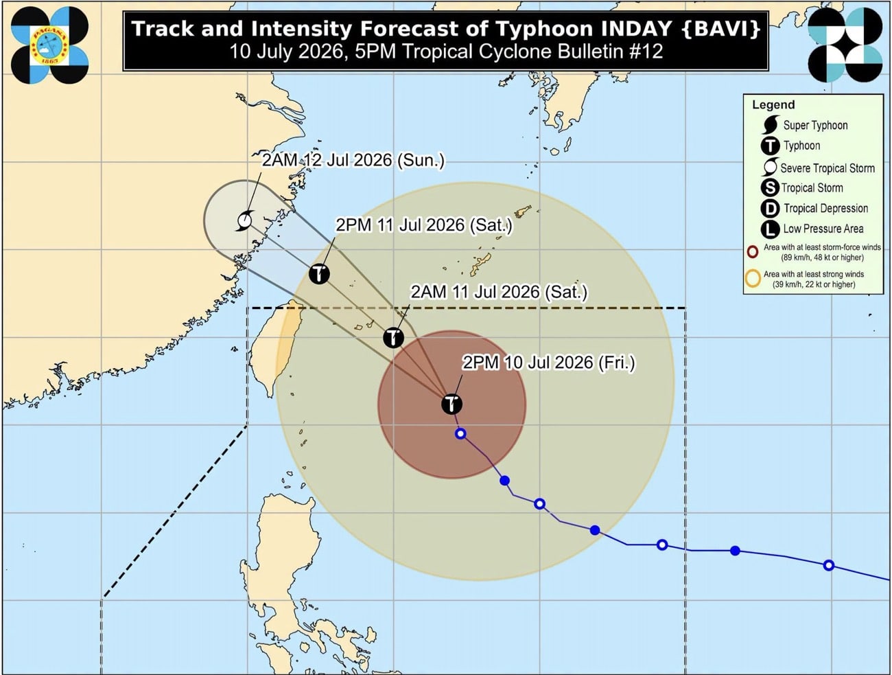
MANILA, Philippines — Tropical Cyclone Wind Signal (TCWS) No. 2 remained hoisted over Batanes and two other areas in Northern Luzon as Typhoon Inday (international name: Bavi) moved northwestward toward the southern islands of Japan on Friday afternoon, the state weather bureau said. In its 5 p.m. weather bulletin, the Philippine Atmospheric, Geophysical, and Astronomical Services Administration (Pagasa) said that Inday was last located 525 kilometers east-northeast of Itbayat, Batanes as of 4 p.m. READ: DepEd: Over 6,100 schools suspend classes due to Inday Inday maintained its strength as it was still carrying a maximum wind speed of 140 kilometers per hour (kph) and gustiness of up to 170 kph. It was moving north-northwestward at 20 kph. It also said that TCWS No. 2 was still in effect over these areas, where wind speeds range from 62 to 88 kph. It then warned of “minor to moderate threat to life and property.” It added that TCWS No. 1 was raised over these areas in Northern Luzon. Under this wind signal, wind speeds range from 39 to 61 with “minimal to minor threat to life and property.” Meanwhile, Pagasa said that Inday is forecast to move generally northwestward while it remains over the Philippine Sea and it may pass closest to Extreme Northern Luzon between Friday evening and early Saturday morning. It will then move towards the southern islands of Japan and may move close over the northern coast of Taiwan. READ: Marcos closely monitoring super typhoon, calls for public vigilance In a separate 5 p.m. weather briefing, weather specialist John Manalo said that the typhoon enhances the southwest monsoon or habagat in bringing heavy rains over the country. “Because of Typhoon Inday’s counter-clockwise movement, it pulls winds coming from the southwest portion of the country and enhances cloudiness and rains experienced by our citizens, particularly those residing in the western portion of the country,” Manalo said in Filipino. Pagasa added that Inday will exit the Philippine area of responsibility (PAR) by Saturday morning or afternoon and will make landfall over the eastern coast of mainland China by Saturday evening or Sunday early morning. “Depending on its timing, because of its scope, it will still have effects in parts of the country even if it is already outside the PAR,” Manalo added. /jpv

多角的分析

経済的影響

台風インディは、直接的な被害によるインフラ復旧コストや農作物への損害に加え、物流の遅延や商業活動の停滞を引き起こす可能性がある。特に、フィリピン北部や西部で強まる南西モンスーンによる豪雨は、インフラへの負荷を高め、復旧作業を困難にする。また、海外への物資供給にも影響が出かねず、広範な経済活動に一時的な停滞をもたらすことが懸念される。

投資家心理

投資家にとって、台風インディは短期的なインフラ関連株(建設、セメントなど)への一時的な需要増をもたらす可能性がある一方、保険会社や航空・海運業には損失リスクとなる。長期的な視点では、気候変動による自然災害の頻発化・激甚化は、フィリピン経済全体の安定性を損なう要因となり得るため、インフラの強靭化やリスク管理能力の高い企業への投資がより重要になるだろう。

社会的影響

バタネス島や北部ルソン地方の住民は、強風による家屋やインフラへの直接的な被害、そして避難生活を余儀なくされる可能性がある。さらに、台風が強化する南西モンスーンは、フィリピン西部にも広範囲な豪雨をもたらし、洪水や土砂災害のリスクを高める。これにより、日常生活への影響や、農作物への被害による食料供給への不安が増大する。教育機関の休校は、子供たちの学習機会の損失にもつながる。

市民の声

台風インディは、フィリピン北部沿岸地域に住む人々の生活に直接的な脅威をもたらしている。強風警報レベル2は、家屋の損壊やインフラの機能不全を引き起こす可能性があり、住民は避難や安全確保に追われる。さらに、台風がもたらす南西モンスーンの強化は、フィリピン西部全域にわたって広範囲な豪雨と洪水を発生させ、多くの人々の生活基盤を脅かす。教育機関の休校は、子供たちの学習機会を一時的に奪うことになる。

背景・歴史的文脈

フィリピンは太平洋の「火山の輪」に位置し、台風銀座とも呼ばれる地域にあり、年間平均20個以上の台風が接近・上陸する。特に9月から11月にかけては、強力な台風の襲来が増加する傾向にある。過去には、2013年の台風ヨランダ(ハイエン)のように、甚大な被害をもたらした事例もあり、気象庁(Pagasa)による早期警戒と避難勧告、そして政府の災害対策能力が常に問われている。近年、気候変動の影響により、台風の強大化や異常気象の頻発化が指摘されており、インフラ整備や防災対策の強化が喫緊の課題となっている。

原文ソース

Inquirer NewsInfo

原文を読む