Signal No. 1 lifted as Tropical Depression Henry moves away from land
Tropical Depression Henry moved away from the Philippine landmass, prompting the weather bureau to lift Signal No. 1 for some areas by 10 AM Tuesday. However, strong winds and thunderstorms are still expected in certain regions due to its outer bands and the southwest monsoon.
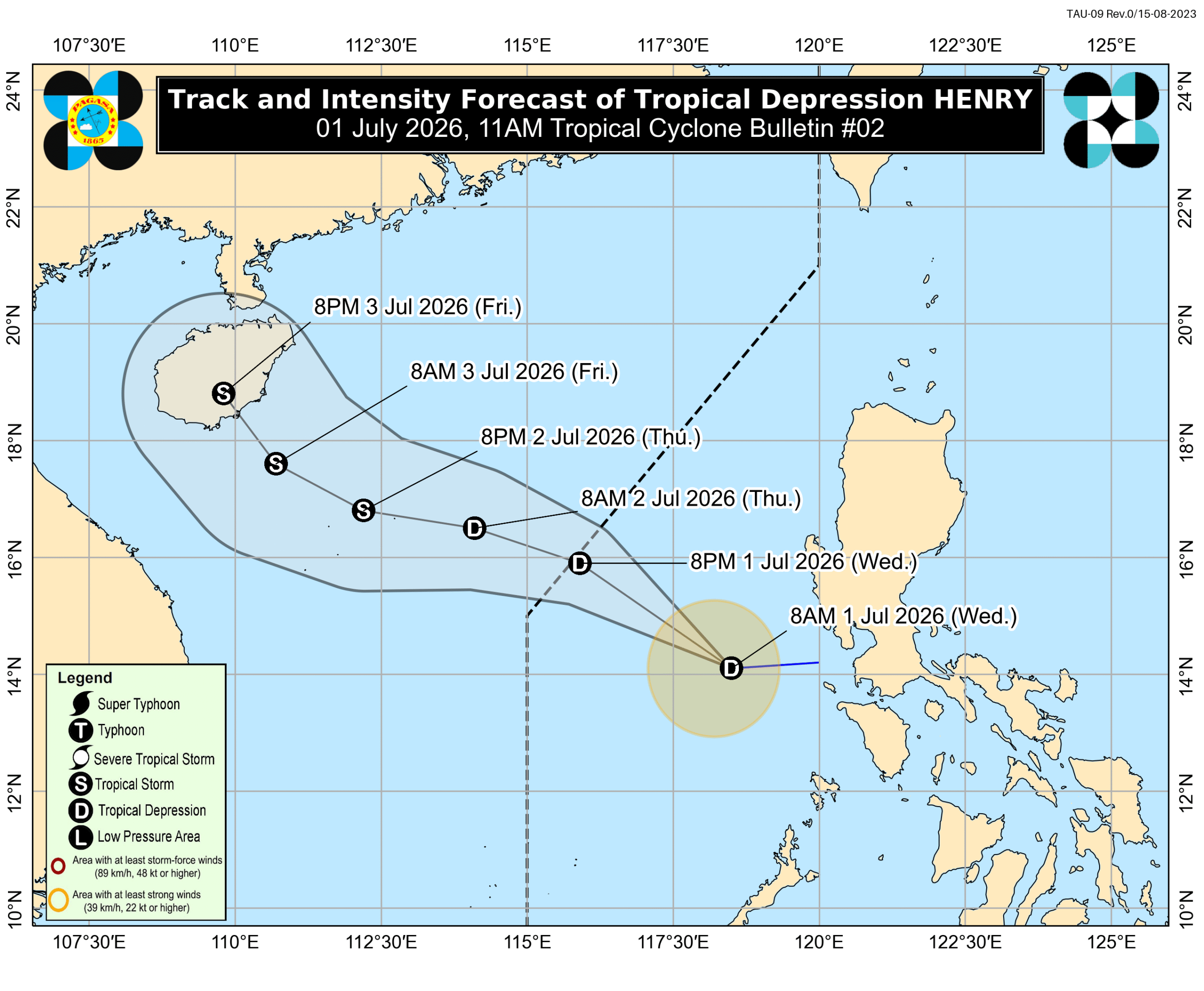
MANILA, Philippines – The weather bureau lifted Signal No. 1 for Tropical Depression Henry late Wednesday morning, July 1, as the tropical cyclone continued to move away from Philippine landmass. As of 10 am on Wednesday, Henry was located 240 kilometers west southwest of Abucay, Bataan, moving west at 25 kilometers per hour (km/h). The tropical depression maintained its strength, with maximum sustained winds of 45 km/h and gustiness of up to 55 km/h. It had developed only hours earlier, at 2 am, after crossing land as a low pressure area. The Philippine Atmospheric, Geophysical, and Astronomical Services Administration (PAGASA) earlier placed several areas in Zambales and in Bataan, as well as Lubang Islands — part of Occidental Mindoro — under Signal No. 1 due to strong winds from Henry. Though Signal No. 1 has been lifted, the periphery or outer bands of the tropical depression and the southwest monsoon or habagat are still bringing strong to gale-force gusts to these areas: Wednesday, July 1 Batanes, Cagayan, Ilocos Norte, Pangasinan, Zambales, Bataan, Tarlac, Nueva Ecija, Pampanga, Bulacan, Metro Manila, Calabarzon, Mimaropa Thursday, July 2 Batanes, Cagayan, Pangasinan, Zambales, Bataan, Palawan Friday, July 3 Batanes, Cagayan, Pangasinan, Zambales, Palawan PAGASA also said in an 11 am advisory on Wednesday that both Henry and the southwest monsoon “are now less likely to bring significant rainfall” to the western portion of Southern Luzon. But scattered rain and thunderstorms remain possible in Mimaropa, Zambales, Bataan, Cagayan, Isabela, Batangas, Western Visayas, the Negros Island Region, the Zamboanga Peninsula, Basilan, and Tawi-Tawi within 24 hours. In addition, up to moderate seas persist in the following seaboards on Wednesday: Seaboards of Babuyan Islands and Zambales; northern seaboards of Cagayan and Ilocos Norte; western seaboards of Pangasinan, Bataan, and Kalayaan Islands – waves up to 2.5 meters high Seaboards of Batanes, Isabela, northern Aurora, Ilocos Sur, La Union, and Lubang Islands; western seaboards of Bataan, Batangas, and Palawan; remaining seaboards of Ilocos Norte and Kalayaan Islands – waves up to 2 meters high Small vessels should take precautionary measures, or avoid sailing, if possible. Henry, the Philippines’ eighth tropical cyclone for 2026 and the first for July, could leave the Philippine Area of Responsibility (PAR) on Wednesday evening or early Thursday morning, July 2. Outside PAR, Henry might intensify into a tropical storm by Thursday evening. PAGASA’s latest estimates show nine to 13 tropical cyclones could form within or enter PAR from July to December 2026. Here is the breakdown per month: July – 2 to 4 August – 2 to 4 September – 2 or 3 October – 1 or 2 November – 1 or 2 December – 1 or 2 Formation inside or entry into PAR does not necessarily mean automatic impact on Philippine weather and sea conditions, as that would depend on multiple factors, including the location, track, and intensity of a tropical cyclone. – Rappler.com
多角的分析
熱帯低気圧「ヘンリー」の影響は限定的であったものの、フィリピンは年間を通じて多くの台風に見舞われるため、農業や漁業への継続的な影響が懸念されます。特に、これらの産業は多くの国民の生計を支えているため、被害は直接的に家計を圧迫する可能性があります。また、インフラへの被害は復旧にコストがかかり、経済成長の足かせとなることもあります。
今回の熱帯低気圧「ヘンリー」による影響は軽微であったため、短期的な投資判断への影響は限定的と見られます。しかし、フィリピンの気候変動リスクは長期的な投資環境を左右する要因となり得ます。特に、農業関連、インフラ、保険セクターへの投資は、台風シーズンにおけるリスク評価が不可欠となります。
熱帯低気圧「ヘンリー」の通過に伴い、一部地域では強風や雷雨が予想されており、屋外で働く労働者や、脆弱な住居に住む人々は直接的な影響を受ける可能性があります。また、交通機関への影響は、通勤・通学に支障をきたし、日常生活に混乱をもたらすことも考えられます。特に、沿岸部や低地の住民は、洪水や高潮のリスクに常に晒されています。
熱帯低気圧「ヘンリー」の警報が解除されたことは一安心ですが、依然として強風や雷雨の可能性があるため、外出には注意が必要です。特に、屋外での作業が多い人々や、交通機関の遅延が懸念される地域に住む人々は、日々の生活に影響を受ける可能性があります。また、食料品や日用品の価格変動も、台風の規模によっては起こり得ます。
背景・歴史的文脈
フィリピンは「太平洋の火の輪」に位置し、環太平洋火山帯の一部であるため、地震や火山活動の影響を受けやすい地域です。さらに、太平洋の西部に位置するため、熱帯低気圧の通り道となっており、年間平均20個もの台風がフィリピンに接近または上陸します。これらの気象現象は、フィリピンの地理的条件と気候パターンに起因しており、過去数十年間にわたり、多くの地域で大規模な被害をもたらしてきました。特に、沿岸部や低地では、高潮や洪水のリスクが高く、インフラの脆弱性も相まって、復旧には多大な時間とコストがかかるのが現状です。
原文ソース
Rappler Philippines