Vietnam Braces for First Tropical Storm of 2026
Vietnam is on high alert as the first tropical storm of 2026, Maysak, approaches, with warnings issued for northern coastal areas. Meteorological authorities caution against strong winds, high waves impacting fishing and cargo vessels, and potential coastal flooding.
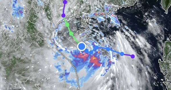
SOCIALIST REPUBLIC OF VIET NAM Government News Kim Loan Forecast path of Maysak According to the National Center for Hydro-Meteorological Forecasting, the storm was centered over waters northwest of the Hoang Sa special zone at 7:00 a.m. on July 3, packing sustained winds of 62–74 kph and gusts of up to 102 kph. The storm is forecast to move north-northwest over the next one to two days before entering the Gulf of Tonkin and making landfall along the coast of Quang Ninh on July 5. It is expected to maintain force 8 winds with gusts reaching force 10 as it moves inland. By July 6, the storm is forecast to weaken into a tropical depression before further dissipating into a low-pressure area over southern Guangxi, China. Authorities warned that the storm could affect 12 northern localities, including Quang Ninh, Hai Phong, Hung Yen, Ninh Binh, Thanh Hoa, Lang Son, Cao Bang, Ha Giang, Bac Ninh, Thai Nguyen and Ha Noi. The storm is currently generating force 6–7 winds across the northwestern part of the East Sea, including the Hoang Sa special zone, with force 8 winds near its center and gusts of up to force 10. Its influence is expected to spread to the Gulf of Tonkin from the night of July 3. Wave heights of 2–4 meters and rough seas are forecast, posing risks to fishing vessels, cargo ships, tourist boats and other marine activities. Fishing operations, maritime transport and coastal tourism may face disruptions. From the afternoon of July 4, coastal areas of Quang Ninh, Hai Phong and Hung Yen are expected to experience force 6 winds, increasing to force 7–8 near the storm's center, with gusts of up to force 9–10. Sea waves along the coast may reach 2–3 meters, while storm surge could raise sea levels by 0.3–0.5 meters. Residents and vessels operating in affected areas have been advised to closely monitor official forecasts and take necessary precautions./. ONLINE NEWSPAPER OF THE GOVERNMENT OF THE SOCIALIST REPUBLIC OF VIET NAM Editor-in-chief: Nguyen Hong Sam License: No. 102/GP-BTTTT dated on April 15, 2024. Head office: No. 16, Le Hong Phong - Ba Dinh - Ha Noi Tel: 080 43162 – 080 48440; Fax: 080 48924 Email: [email protected]
多角的分析
熱帯低気圧の接近は、ベトナム北部の経済活動に一時的ながらも無視できない影響を与える。特に漁業、海上輸送、沿岸部の観光業は直接的な被害を受ける可能性がある。これらの産業はベトナム経済、特に地方経済において重要な役割を担っており、短期的な生産性の低下やインフラへの損害は、地域経済の回復に時間を要する要因となりうる。また、農作物への被害も懸念され、食料供給や価格にも影響を与える可能性がある。
投資家にとって、熱帯低気圧の接近は短期的なリスク要因となる。特に、インフラ関連企業や沿岸部で事業を展開する企業は、物理的な損害や操業停止のリスクに直面する。しかし、ベトナム経済の回復力と、政府による迅速な復旧支援策への期待から、長期的な投資判断に大きな影響を与える可能性は低い。むしろ、災害復旧やインフラ強化に関連する投資機会が生まれる可能性も考慮すべきだろう。
熱帯低気圧「メーサク」の接近は、ベトナム北部沿岸地域に住む人々の生活に直接的な影響を与える。特に、漁業に依存するコミュニティでは生計手段が脅かされる。また、強風や高波、浸水のリスクは、住民の安全確保と避難行動を必要とする。政府や地方自治体による避難勧告や支援体制の整備が、住民の不安軽減と被害最小化の鍵となる。クアンニン省やハイフォン市などの沿岸地域では、早めの避難と物資の備蓄が呼びかけられており、日々の生活への影響は避けられない。
ベトナム北部沿岸地域に住む市民にとって、熱帯低気圧の接近は生活への直接的な脅威となる。漁業関係者は漁に出られなくなり、収入が途絶える。沿岸部の住民は浸水や家屋への被害を心配し、避難を余儀なくされる場合もある。政府からの情報提供や避難指示に迅速に対応することが求められる。特に、クアンニン省やハイフォン市といった沿岸地域では、日常の交通網やインフラが寸断される可能性もあり、生活必需品の調達にも影響が出かねない。
背景・歴史的文脈
ベトナムは、南シナ海に面した長い海岸線を持つため、熱帯低気圧や台風の影響を受けやすい国である。特に北部沿岸地域は、季節的に熱帯低気圧の通り道となることが多い。近年、気候変動の影響により、異常気象の頻度や強度が増加する傾向にある。2026年初の熱帯低気圧である「メーサク」の接近は、ベトナム政府にとって、気候変動対策、災害予防、および国民の安全確保という喫緊の課題に改めて取り組む必要性を示唆している。過去の台風被害からの教訓を生かし、早期警報システムや避難体制の強化が継続的に求められている。
原文ソース
Bao Chinh Phu