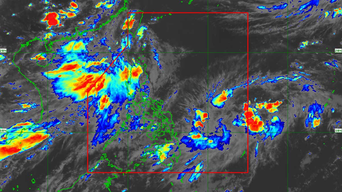
TD Haishen approaches PAR; Habagat remains main rain threat
A tropical depression, internationally named Haishen, is expected to enter the Philippine Area of Responsibility (PAR) within 24 hours. However, the state weather bureau predicts minimal direct impact from Haishen, with the southwest monsoon (habagat) remaining the primary source of rain for parts of Luzon.
MANILA, Philippines — A tropical depression is expected to enter the Philippine Area of Responsibility (PAR) within the next 24 hours, but the southwest monsoon, or habagat, will remain the main rain-bearing weather system over parts of Luzon, the state weather bureau said Monday. In its latest public weather forecast, the Philippine Atmospheric, Geophysical and Astronomical Services Administration (Pagasa) said the tropical depression, internationally named Haishen, was located 1,205 kilometers east of Eastern Visayas as of 3 p.m., with maximum sustained winds of 55 kilometers per hour near the center and gusts of up to 70 kph as it moved northwestward at 10 kph. READ: Tropical depression forms outside PAR – Pagasa Weather specialist Grace Castañeda-Carpio said while the tropical depression could enter PAR within the next 24 hours, it is not expected to directly affect any part of the country. Pagasa said the tropical depression is forecast to move generally westward and northward over the next 12 hours and may briefly intensify into a tropical storm. It could enter PAR as early as Monday night or Tuesday morning, when it would be assigned the local name Jossie. After entering PAR, Pagasa expects the system to weaken back into a tropical depression as it moves quickly across the eastern portion of the country’s area of responsibility before exiting by Wednesday as a low-pressure area. Habagat continues to affect Luzon Despite the approaching tropical depression, Pagasa said the southwest monsoon continues to affect Luzon. Cloudy skies with scattered rains and thunderstorms are expected over the Ilocos Region, Benguet, Zambales, Bataan and Tarlac due to the southwest monsoon. PAGASA warned that moderate to heavy rains, at times, could trigger flash floods or landslides in these areas. READ: Death toll from heavy rains in Mindanao, Visayas now at 20 Metro Manila and the rest of Luzon will have partly cloudy to cloudy skies with isolated rain showers or thunderstorms, also due to the southwest monsoon. PAGASA said severe thunderstorms may still bring short periods of heavy rain that could cause flash floods or landslides. “We are not expecting continuous heavy rainfall, but brief periods of heavy rain are still possible. Again, we advise the public to remain cautious,” Castañeda-Carpio said. Meanwhile, the rest of the country will experience partly to mostly cloudy skies, with isolated rain showers or thunderstorms. PAGASA said severe thunderstorms may also bring brief but intense downpours that could trigger flash floods or landslides. READ: 35 tourists stranded in Batanes as Inday exits PH Moderate to rough seas over Luzon PAGASA also forecast moderate to strong southwest to south winds over Luzon, where coastal waters will be moderate to rough, with wave heights ranging from 1.5 to 3.1 meters. Visayas and Mindanao will have light to moderate southeast to south winds and slight to moderate coastal waters, with waves ranging from 0.6 to 2.1 meters. While no gale warning has been raised, Castañeda-Carpio advised those planning to travel by sea, particularly along the western seaboard of Luzon, to remain cautious due to moderate to rough sea conditions. Pagasa urged the public to continue monitoring its official weather advisories as the southwest monsoon remains the country’s dominant weather system even as the tropical depression approaches PAR./dp
多角的分析
熱帯低気圧「ハイシェン」のフィリピンへの直接的な影響は限定的と予測されているものの、モンスーンによる雨がルソン島の一部地域に影響を与える可能性は、農業やインフラに短期的な影響を与える可能性がある。特に、 flash flood や土砂崩れのリスクは、農作物の被害や交通網の寸断につながりうる。これは、国内の食料供給や物流コストに微細ながらも影響を与える要因となりうる。過去のモンスーンによる被害事例を鑑みると、インフラの脆弱性が露呈する可能性も否定できない。
現時点では、熱帯低気圧「ハイシェン」の接近は、フィリピン経済全体に大きな影響を与える投資リスクとは見なされていない。しかし、モンスーンによる雨がルソン島の一部地域に影響を及ぼす可能性は、地域的なサプライチェーンや一部の産業(農業、観光)に一時的な混乱をもたらすリスク要因として考慮されるべきである。投資家は、短期的な影響よりも、長期的な気候変動による異常気象の頻度増加と、それに対するインフラのレジリエンス(強靭性)の強化動向を注視する必要があるだろう。
熱帯低気圧「ハイシェン」の直接的な影響は軽微と予測されているものの、モンスーンによる雨は、ルソン島北部の一部地域、特にイロコス地方やベンゲット州などの山岳地帯において、 flash flood や土砂崩れのリスクを高める。これらの地域に住む住民、特に脆弱なコミュニティでは、家屋の損壊や避難生活を余儀なくされる可能性がある。Pagasaは注意を呼びかけているが、過去の事例では、迅速な避難勧告や支援体制の整備が追いつかず、被害が拡大したケースも少なくない。住民の安全確保と、災害への備えが引き続き問われる。
フィリピン市民、特にルソン島北部や山岳地帯に住む人々にとって、熱帯低気圧「ハイシェン」の接近よりも、モンスーンによる雨の方がより身近な懸念事項となる。 flash flood や土砂崩れの危険性は、日々の生活に直接的な不安をもたらす。Pagasaからの注意喚起は重要だが、過去の経験から、情報伝達の遅れや、避難場所へのアクセス、そして避難後の生活再建への不安がつきまとう。特に、脆弱なインフラや住居を持つ家庭では、警報が出た際の迅速な行動と、地域コミュニティでの相互支援が不可欠となる。
背景・歴史的文脈
フィリピンは、太平洋の「火山の輪」と台風銀座に位置するため、年間を通じて様々な自然災害に見舞われる。特に、6月から11月にかけてはモンスーン(ハバガット)の季節であり、熱帯低気圧や台風の接近・上陸が頻繁に発生する。これらの気象現象は、広範囲にわたる豪雨、 flash flood、土砂崩れを引き起こし、甚大な被害をもたらしてきた。過去には、2013年の台風ヨランダ(ハイエン)のような壊滅的な被害も発生しており、気象庁(Pagasa)による早期警報と、政府および国民の防災意識の向上が、被害軽減の鍵となっている。
原文ソース
Inquirer NewsInfo