Tropical Depression Henry leaves PAR on same day it developed
Tropical Depression Henry left the Philippine Area of Responsibility (PAR) at 8 PM on July 1, just 18 hours after its development, according to the Philippine Atmospheric, Geophysical, and Astronomical Services Administration (PAGASA). The cyclone was moving northwest and showed potential for intensification.
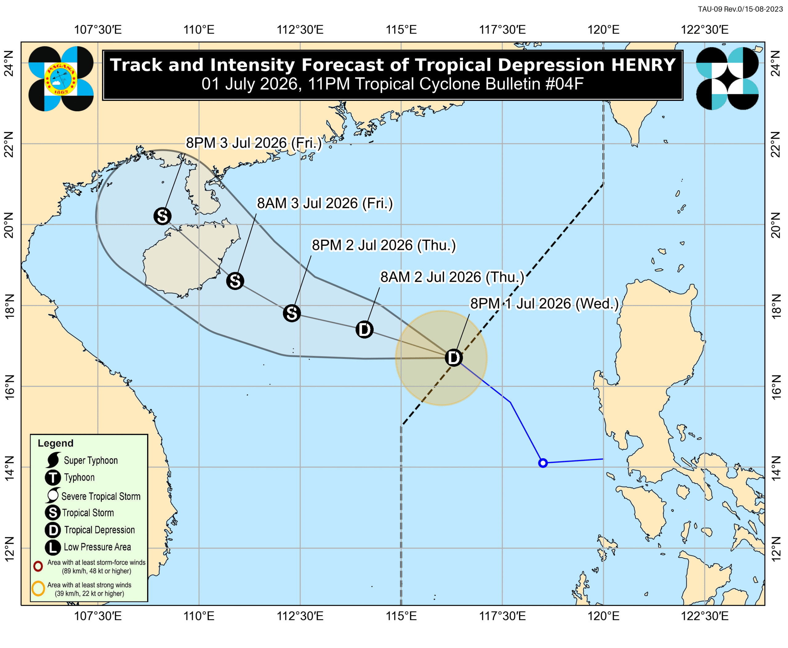
Tropical Depression Henry left the Philippine Area of Responsibility (PAR) at 8 PM on Wednesday, July 1, 18 hours after it developed inside PAR. The Philippine Atmospheric, Geophysical, and Astronomical Services Administration (PAGASA) said Henry was already 470 kilometers west of Bacnotan, La Union, as of 10 PM. The tropical depression is moving northwest at a relatively fast 30 kilometers per hour (km/h). It continues to have maximum sustained winds of 45 km/h and gustiness of up to 55 km/h, but it could intensify into a tropical storm by Thursday, July 2. Before it developed at 2 am on Wednesday, Henry had crossed land as a low pressure area on Tuesday, June 30, affecting Southern Luzon and the Visayas. Moderate to heavy rain hit several provinces. Signal No. 1 was briefly raised on Wednesday morning due to strong winds from the tropical depression. Even as Henry moved away, Zambales and Bataan had been told that they may still have scattered rain and thunderstorms because of the tropical depression. Similar conditions are likely in Cavite, Batangas, Occidental Mindoro, Oriental Mindoro, Romblon, Palawan, Western Visayas, the Negros Island Region, the Zamboanga Peninsula, Basilan, and Tawi-Tawi, but due to the southwest monsoon or habagat. Henry’s periphery or outer bands and the southwest monsoon are still bringing strong to gale-force gusts to these areas, too: Thursday, July 2 Batanes, Cagayan, Pangasinan, Zambales, Bataan, Palawan Friday, July 3 Batanes, Cagayan, Pangasinan, Zambales, Palawan Moderate sea conditions are also expected to continue in certain seaboards in Luzon within 24 hours. Seaboards of Kalayaan Islands; western seaboards of Pangasinan and Zambales – waves up to 2.5 meters high Seaboards of Batanes, Babuyan Islands, Ilocos Sur, La Union, and Lubang Islands; northern. seaboards of mainland Cagayan and Ilocos Norte; western seaboards of Bataan, Batangas, and Palawan – waves up to 2 meters high Small vessels should take precautionary measures, or avoid sailing, if possible. Henry was the Philippines’ eighth tropical cyclone for 2026, and the first for July. PAGASA’s latest estimates show nine to 13 tropical cyclones could form within or enter PAR from July to December 2026. Here is the breakdown per month: July – 2 to 4 August – 2 to 4 September – 2 or 3 October – 1 or 2 November – 1 or 2 December – 1 or 2 Formation inside or entry into PAR does not necessarily mean automatic impact on Philippine weather and sea conditions, as that would depend on multiple factors, including the location, track, and intensity of a tropical cyclone. – Rappler.com
多角的分析
熱帯低気圧ヘンリーの迅速な通過は、直接的な経済的損害を最小限に抑えたが、フィリピン経済は依然として気象災害の影響を受けやすい。特に農業部門は、予期せぬ豪雨や強風により、収穫量やインフラに打撃を受けるリスクを常に抱えている。過去の事例では、大規模な台風が数日間にわたり経済活動を麻痺させ、復旧に多大なコストを要したケースも少なくない。今回のケースは、短期的な影響は限定的であったが、長期的な視点では、気候変動への適応策や防災インフラへの投資の重要性を示唆している。
熱帯低気圧ヘンリーの迅速な通過は、短期的な投資リスクを軽減した。しかし、フィリピンは頻繁な気象災害に見舞われる地域であり、投資家は常にその影響を考慮する必要がある。特に、農業、観光、インフラ関連のセクターは、台風や洪水の影響を受けやすい。過去には、大規模な自然災害が株価の急落やサプライチェーンの混乱を引き起こし、外国からの直接投資にも影響を与えた事例がある。投資家は、リスク管理の一環として、気象予報や政府の防災対策を注視し、ポートフォリオの分散を検討することが賢明である。
熱帯低気圧ヘンリーの短期間の通過は、広範囲にわたる大規模な避難や長期的な生活への影響を回避させた。しかし、低気圧が通過する前に影響を受けた地域では、一時的な停電や交通網の混乱が発生し、住民の日常生活に支障をきたした。特に、脆弱なコミュニティや低所得者層は、予期せぬ気象現象によって生計手段を失うリスクに直面しやすい。過去の台風被害では、復旧支援の遅れやインフラの不備が、被災者の生活再建を困難にした事例が報告されている。今回のケースでも、迅速な情報伝達と支援体制の重要性が改めて浮き彫りになった。
熱帯低気圧ヘンリーの発生と迅速な通過は、多くの市民にとって一時的な不安をもたらしたが、幸いにも甚大な被害は回避された。しかし、低気圧が通過する前の段階で、一部地域では雨や強風による影響を受け、日常生活に支障が出た。特に、沿岸部や低地の住民は、常に水害や強風への警戒を怠ることはできない。過去の経験から、台風シーズンには食料や水の備蓄、避難場所の確認など、個々の備えが重要視されている。今回の件も、日頃からの防災意識の重要性を再認識させる出来事となった。
背景・歴史的文脈
フィリピンは、太平洋の「火山の輪」と「台風銀座」に位置し、年間平均20個以上の熱帯低気圧がフィリピンの責任範囲(PAR)内を通過または発生する、世界で最も自然災害に見舞われやすい国の一つである。特に、7月から12月にかけての後半期は台風シーズンであり、過去には「ハイエン」のような壊滅的な被害をもたらした台風も発生している。これらの災害は、フィリピンの経済、社会インフラ、そして人々の生活に深刻な影響を与えてきた。そのため、フィリピン政府は、気象庁(PAGASA)による早期警報システムの強化や、防災・減災対策への投資を継続的に行っているが、広大な国土と多くの島嶼部を持つ地理的条件から、その対策は常に課題となっている。
原文ソース
Rappler Philippines