Tropical Depression Strengthens into Typhoon, Forms East of Philippines, Heads Towards East Sea
Environment
2026年7月24日
3
Nhan Dan
Relations
🇻🇳Vietnam🇵🇭Philippines

General articles are free for 24 hours after publish.

Tropical Depression Strengthens into Typhoon, Forms East of Philippines, Heads Towards East Sea

Share
AI Summary

A tropical depression east of the Philippines has intensified into Typhoon Noul, expected to enter the northeastern East Sea from the night of the 24th to the early morning of the 25th. While direct impact on mainland Vietnam is forecast to be minimal, coastal areas and northern mountainous regions should remain vigilant against heavy rain, landslides, and flooding.

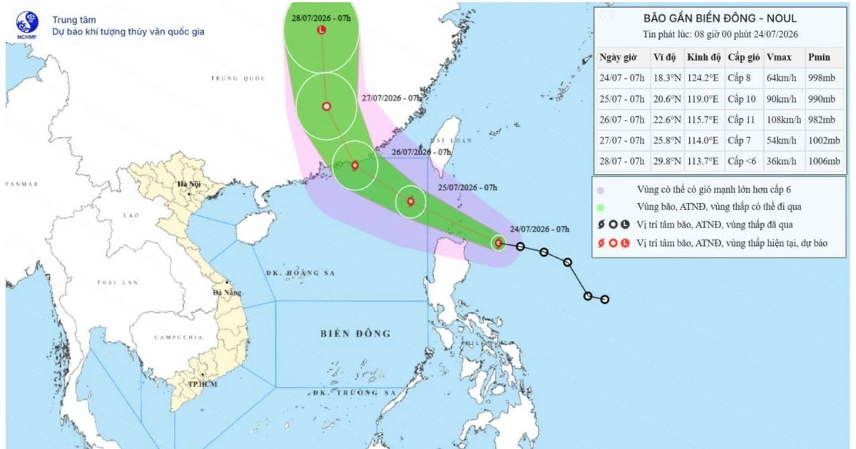
A tropical depression located east of the Philippines has intensified into Typhoon Noul. According to the National Center for Hydro-Meteorological Forecasting, this typhoon is expected to move into the northeastern East Sea from the night of July 24th to the early morning of the 25th, marking it as the second typhoon of the year. It is forecast to make landfall in China's Guangdong province on July 26th, with minimal direct impact anticipated on mainland Vietnam. As of 7:00 AM on July 24th, the typhoon's center was located around 18.3 degrees North latitude and 124.2 degrees East longitude, approximately 210km east of the Philippines' Luzon Island. The maximum wind speed near the center was recorded at level 8 (62-74 km/h), with gusts up to level 10. The typhoon is moving west-northwest at a speed of about 25 km/h. Meteorological experts predict that Typhoon Noul could reach intensities of level 10-11, with gusts up to level 13. By July 27th, the typhoon is expected to weaken into a tropical depression over land in Guangdong province, China, and continue moving northward, gradually dissipating. The affected area is the northeastern part of the East Sea, with a natural disaster risk level of 3. In this region, winds are expected to strengthen from the afternoon of July 24th, escalating from level 6-7 to level 8-9, with wave heights of 3-5 meters. Near the typhoon's center, winds could reach level 10-11 with gusts up to level 13, and wave heights of 4-6 meters, leading to severe sea conditions. Vessels operating in these dangerous zones are at risk of being affected by squalls, tornadoes, strong winds, and large waves. Furthermore, from July 24th to 25th, Northern Vietnam (Bắc Bộ) is expected to experience moderate to heavy rain and thunderstorms, with rainfall amounts ranging from 40-100mm, and localized areas receiving over 200mm. There is a high risk of flash floods and landslides in mountainous and midland areas, as well as flooding in low-lying areas and along rivers. Vigilance is advised. Source: Nhan Dan

0

Original source

Nhan Dan

原文を読む