General articles are free for 24 hours after publish.
Tropical Depression Kiyapo Triggers Signal No. 1 in Northern Philippines
The Philippine Atmospheric, Geophysical, and Astronomical Services Administration (PAGASA) raised Tropical Cyclone Wind Signal No. 1 in several areas in Northern Philippines before dawn on Thursday, July 23, as Tropical Depression Kiyapo approaches. The storm may intensify into a tropical storm over the weekend.
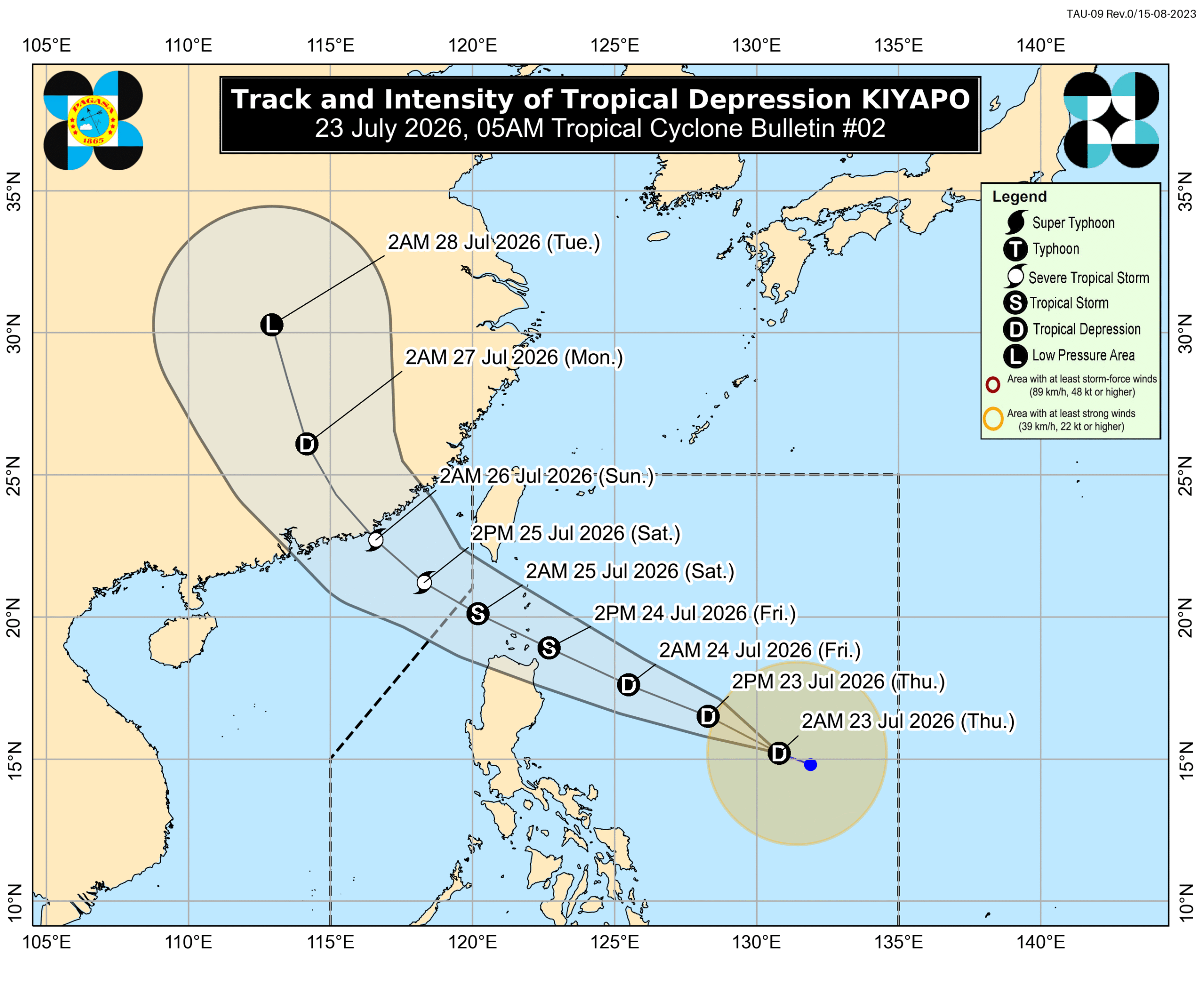
More areas in Northern Philippines were placed under Tropical Cyclone Wind Signal No. 1 before dawn on Thursday, July 23, as Tropical Depression Kiyapo continues its approach. The Philippine Atmospheric, Geophysical, and Astronomical Services Administration (PAGASA) issued the warning to prepare residents for strong winds. As of 4 a.m. on Thursday, Kiyapo was located 950 kilometers east of Central Luzon, moving west northwest at a slightly reduced speed of 20 kilometers per hour. It maintains maximum sustained winds of 45 km/h and gusts of up to 55 km/h. PAGASA's latest forecast indicates that Kiyapo may pass very close to the northeastern part of mainland Cagayan on Friday morning or afternoon, July 24. It could then make landfall or pass very close to Cagayan's Babuyan Islands in the afternoon or evening. The tropical depression is also forecast to intensify into a tropical storm on Friday and potentially into a severe tropical storm by Saturday, July 25. The areas currently under Signal No. 1 as of 5 a.m. on Thursday include: Batanes Cagayan (including Babuyan Islands) Isabela Apayao Abra Kalinga Eastern and central parts of Mountain Province (Paracelis, Natonin, Barlig, Sadanga, Bontoc, Besao, Sagada) Eastern and central parts of Ifugao (Mayoyao, Aguinaldo, Alfonso Lista, Banaue, Hingyon, Lagawe) Ilocos Norte Northern part of Ilocos Sur (Cabugao, Sinait, San Juan, Magsingal, Santo Domingo, Bantay, San Ildefonso, San Vicente) Northern part of Aurora (Dilasag, Casiguran) The highest possible signal could be Signal No. 2, with PAGASA not ruling out Signal No. 3 if Kiyapo strengthens significantly while crossing the Batanes-Babuyan Islands area. In addition to the direct wind threat, the southwest monsoon (habagat) and Kiyapo's outer bands are expected to bring strong to gale-force gusts to various parts of the country. These include most of Mindanao, Siquijor, Bohol, and Southern Leyte on Thursday; most of the country on Friday; and most of Luzon, Visayas, Zamboanga Peninsula, Misamis Occidental, Camiguin, Dinagat Islands, and Davao Oriental on Saturday. Regarding rainfall, moderate to intense rain is expected in parts of Northern Luzon starting Friday. Heavy to intense rainfall (100-200 mm) is forecast for Cagayan and Apayao, while moderate to heavy rain (50-100 mm) is expected in Batanes, Isabela, Kalinga, Abra, Ilocos Norte, and other northern provinces. The southwest monsoon will also bring moderate to heavy rain to the western parts of the country, affecting areas like Negros Oriental, Zamboanga del Norte, Zamboanga Sibugay, Zamboanga del Sur, Lanao del Norte, Lanao del Sur, Maguindanao del Norte, Sultan Kudarat, Sarangani, Antique, Negros Occidental, Occidental Mindoro, and La Union. Flooding and landslides are likely in areas affected by Kiyapo and the southwest monsoon. Several seaboards are also under advisories for small vessels on Thursday due to rough seas, with waves up to 3 meters high expected in the eastern seaboard of Davao Oriental. Other eastern and western seaboards are also experiencing moderate to rough seas. Kiyapo is the 11th tropical cyclone to affect the Philippines in 2026 and the fourth for July. It is projected to exit the Philippine Area of Responsibility by Saturday morning or noon. – Rappler.com
Original source
Rappler Philippines