Tropical Depression Kiyapo intensifies into Tropical Storm, nears Northern Philippines
Environment
2026年7月24日
5
Rappler Philippines

General articles are free for 24 hours after publish.

Tropical Depression Kiyapo intensifies into Tropical Storm, nears Northern Philippines

Share
AI Summary

Tropical Depression Kiyapo has intensified into a tropical storm and is approaching Northern Philippines. With maximum sustained winds of 65 km/h, it is expected to make landfall in Cagayan province and may further strengthen over the West Philippine Sea.

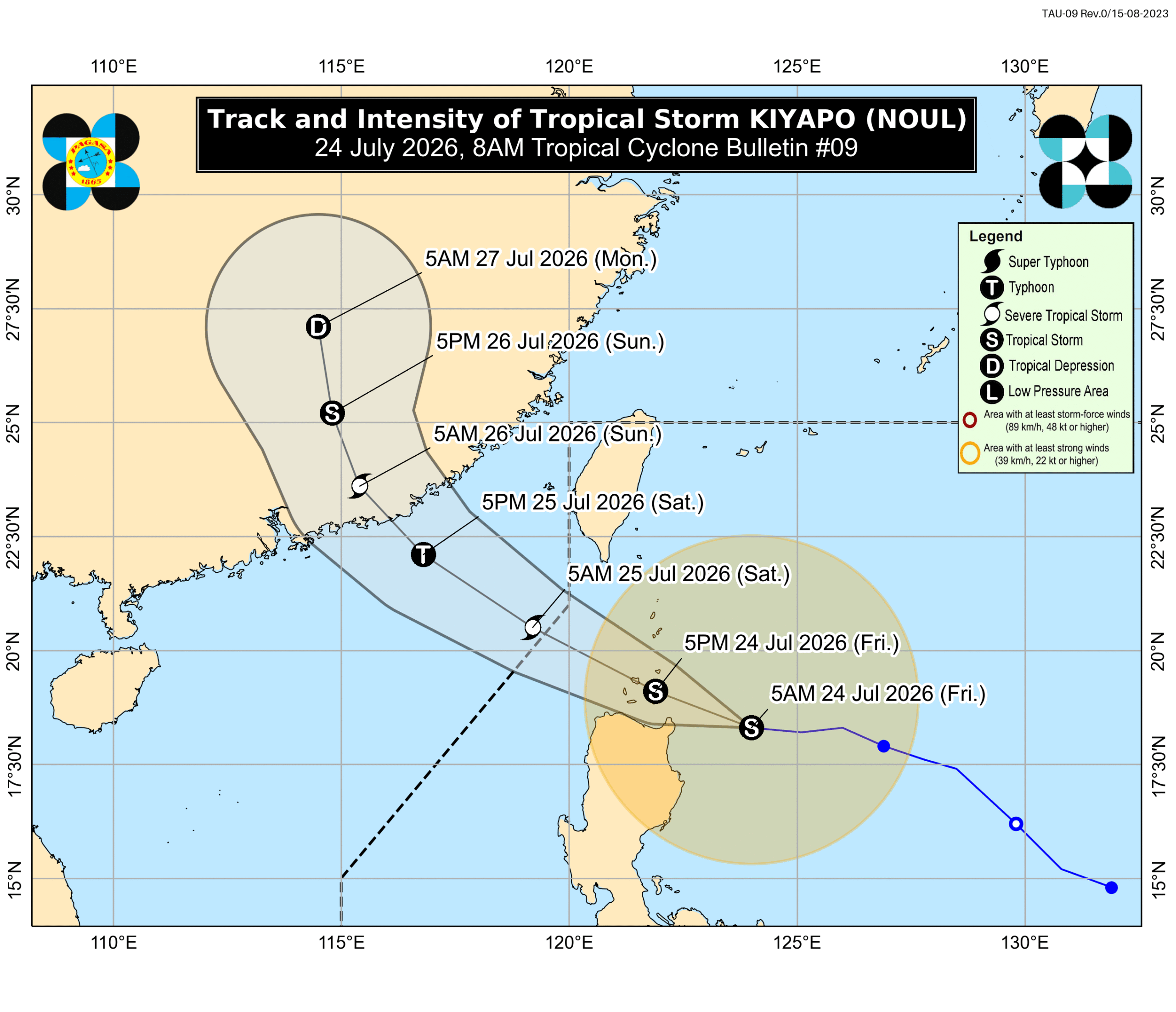
Kiyapo has intensified from a tropical depression into a tropical storm, with maximum sustained winds increasing to 65 kilometers per hour (km/h) and gustiness to 80 km/h as of Friday, July 24. The Philippine Atmospheric, Geophysical, and Astronomical Services Administration (PAGASA) reported this intensification. Following its upgrade, Kiyapo was assigned the international name Noul, contributed by North Korea, meaning "red sky." As of 7 am on Friday, the storm was located 260 kilometers east of Aparri, Cagayan, moving west at a slower pace of 20 km/h. PAGASA forecasts Kiyapo to pass close to the northeastern mainland of Cagayan on Friday morning or afternoon, with a potential landfall in the Babuyan Islands in the afternoon or evening. The storm may further strengthen into a severe tropical storm after passing the islands and could potentially undergo rapid intensification over the West Philippine Sea, possibly becoming a typhoon. The storm is bringing significant rainfall to Northern Luzon, with scattered rain and thunderstorms also affecting Central and Southern Luzon, including Metro Manila and Calabarzon, on Friday. Over the next two days, heavy to intense rainfall is expected in Batanes, Cagayan, Apayao, and Ilocos Norte on Friday, and moderate to heavy rain in several northern provinces on Saturday. Meanwhile, the southwest monsoon, or habagat, continues to bring considerable rainfall to the western side of the country. Mindanao's weather is gradually improving, though scattered rain and thunderstorms persist due to the monsoon. Mimaropa, Western Visayas, and the Negros Island Region are among the areas most affected by the habagat. Tropical Cyclone Wind Signals (TCWS) have been raised. Signal No. 2, indicating gale-force winds, is in effect for Batanes, the northern part of mainland Cagayan and Babuyan Islands, and the northern part of Ilocos Norte. Signal No. 1, indicating strong winds, covers a wider area across Northern Luzon. Sea conditions remain dangerous, particularly along the seaboards of Northern Luzon. Waves up to 5.5 meters high are expected in the waters of Batanes and Babuyan Islands, making travel risky for all vessels. Other coastal areas also face rough to very rough seas. Kiyapo is the 11th tropical cyclone to enter the Philippine Area of Responsibility in 2026 and the fourth for July. It is projected to exit the PAR by Saturday morning, July 25, and head towards China. Source: Rappler Philippines

0

Original source

Rappler Philippines

原文を読む