Satellite Data Reveals Widespread Flooding in Southern Philippines After Typhoon Inday Rains
Environment
2026年7月12日
5
Philstar Nation

Satellite Data Reveals Widespread Flooding in Southern Philippines After Typhoon Inday Rains

AI サマリー

The Philippine Space Agency (PhilSA) has confirmed widespread flooding in southern Mindanao following heavy rains enhanced by Typhoon Inday, with satellite data highlighting severe inundation in parts of Cotabato and the Bangsamoro region.

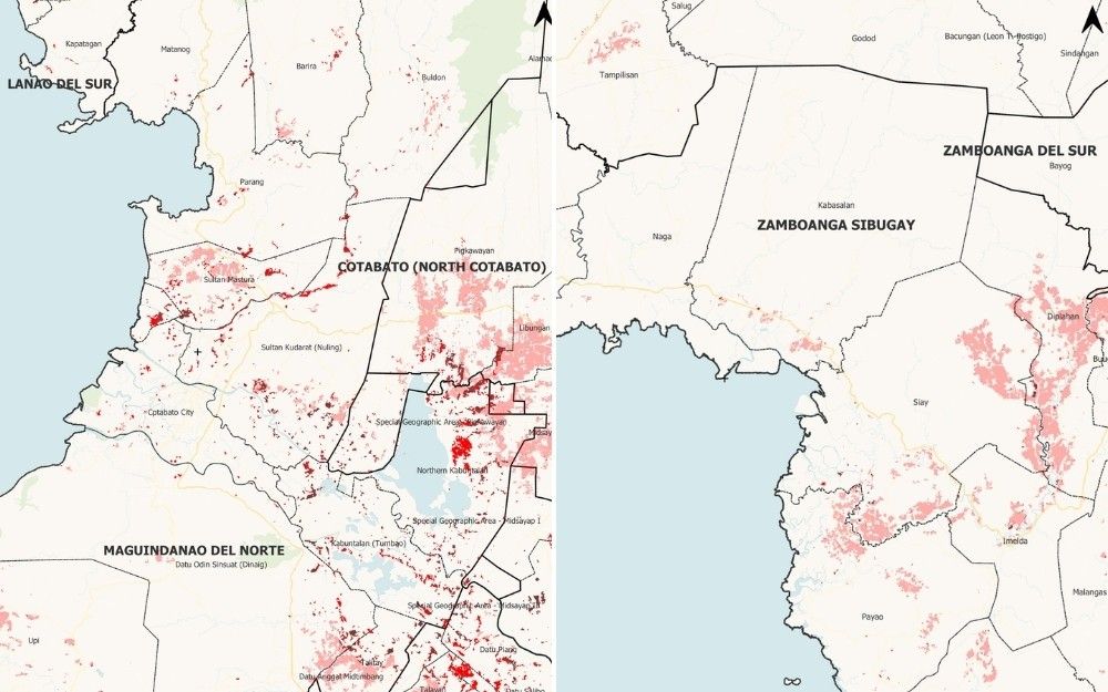
MANILA, Philippines — Satellite extent maps released by the Philippine Space Agency show heavy flooding in parts of Cotabato and nearby Bangsamoro areas after monsoon rains enhanced by Typhoon Inday (international name: Bavi) soaked large parts of Mindanao. The maps, produced by PhilSA using satellite imagery captured on July 10 at around 5:31 a.m., point to flooded areas in red, flood-affected physical rice areas in pink and flooded other crop areas in brown. Based on the maps, the densest and most extensive visible flooding appears in the Cotabato-Bangsamoro corridor, particularly parts of Cotabato, the Bangsamoro's Special Geographic Area and nearby areas of Maguindanao del Sur. Large flood clusters are also visible in southwestern Lanao del Sur, especially near Balabagan and Malabang, and in parts of Maguindanao del Sur adjoining Cotabato. The agency cautioned, however, that the maps may underestimate flooding in urban and densely vegetated areas because of the complexity of radar backscatter from those surfaces. The maps remain subject to ground validation, PhilSA said. Flood clusters in Mindanao. The strongest concentration of red flooded areas appears in central and eastern portions of the Cotabato-Bangsamoro belt. The map covering Cotabato, Maguindanao del Norte and Maguindanao del Sur shows widespread red and pink markings across low-lying communities, including areas around the Special Geographic Area and nearby towns. Another map covering Maguindanao del Sur and Sultan Kudarat also shows a heavy flood footprint, particularly in eastern sections of Maguindanao del Sur. A separate map of Lanao del Sur shows intense red clusters in the Balabagan-Malabang area. In contrast, maps of the Zamboanga Peninsula and Misamis areas show more scattered red flooding, although several areas still indicate wide stretches of flood-affected rice land. The broadest pink zones—which PhilSA identifies as flood-affected physical rice areas—appear in parts of Lanao del Norte, Zamboanga del Sur and Zamboanga Sibugay, as well as sections of Sultan Kudarat and Cotabato. In Lanao del Norte, the maps show extensive pink areas across the Lala-Kapatagan corridor and nearby towns. In Zamboanga del Sur, large pink patches are visible in the Mahayag-Tambulig area and adjoining localities. Zamboanga Sibugay also shows broad affected rice areas around the Diplahan-Imelda-Siay corridor. The patterns suggest that even in areas where floodwaters appear less concentrated, agricultural communities may still have sustained widespread inundation. At least 17 people have died due to landslides induced by cyclone Inday, which entered the Philippine area of responsibility Wednesday, July 8, as a super typhoon. PhilSA said the flood extent analysis used Sentinel-1 Synthetic Aperture Radar data and artificial intelligence to detect inundated areas. Sentinel-1 is a European Space Agency satellite. SAR, meanwhile, is useful during storms because it can capture images through cloud cover and regardless of daylight conditions. PhilSA said the mapping supports the National Disaster Risk Reduction and Management Council in monitoring the situation and helping prioritize response.

多角的分析

経済的影響

衛星データによる広範な浸水域の特定は、被害を受けた農業地域、特に稲作地帯への経済的影響の大きさを物語っている。コタバトやバンサモロ地域はフィリピン有数の農業地帯であり、今回の被害は食料供給や農家所得に直接的な打撃を与える可能性がある。復旧にはインフラ整備や代替作物の支援など、長期的な経済的介入が必要となるだろう。また、災害対応や復興のための公的資金の投入は、国家財政にも影響を与える可能性がある。

投資家心理

今回の洪水被害は、特に農業関連企業やサプライチェーンに投資している投資家にとって、リスク要因となる。被害地域の生産能力の低下は、関連企業の収益に影響を与える可能性がある。しかし、長期的には、災害復旧やインフラ再建に関連するプロジェクトへの投資機会も生まれる可能性がある。投資家は、被害の規模と復旧計画を注視し、リスクと機会のバランスを慎重に評価する必要がある。

社会的影響

洪水は、特に低所得者層や農業従事者に深刻な影響を与える。住居の損壊、家財道具の喪失、そして生計手段の喪失は、被災者の生活を直撃する。コタバトやバンサモロ地域では、農業が主要な収入源であるため、作物の被害は食料不安や貧困の悪化につながる可能性がある。また、避難生活による衛生問題や感染症のリスクも懸念される。地域社会の結束力や、政府・NGOによる迅速かつ効果的な支援が、被災者の回復力にとって極めて重要となる。

市民の声

今回の洪水は、ミンダナオ南部、特にコタバトやバンサモロ自治地域に住む多くの市民の生活に直接的な影響を与えている。衛星データで示された広範囲の浸水は、家屋の損壊、農作物の全滅、そして避難を余儀なくされた人々の苦境を物語っている。農業に依存する地域では、生計手段の喪失が深刻な問題となる。市民は、食料、水、住居、そして医療へのアクセスを確保するために、政府や支援団体からの迅速な援助を必要としている。また、将来的な同様の災害への備えとして、早期警報システムや避難計画の強化が求められている。

背景・歴史的文脈

フィリピンは、台風やモンスーンによる豪雨の影響を受けやすい「環太平洋火山帯」に位置し、国土の多くが低地であるため、洪水の被害を受けやすい。特にミンダナオ島南部は、近年、気候変動による異常気象の頻発化と、開発の遅れによるインフラの脆弱性が重なり、災害リスクが高まっている。今回の「インディ」による洪水は、こうした構造的な問題を改めて浮き彫りにした。過去にも同様の豪雨による被害は繰り返されており、防災・減災対策の強化が喫緊の課題となっている。

原文ソース

Philstar Nation

原文を読む