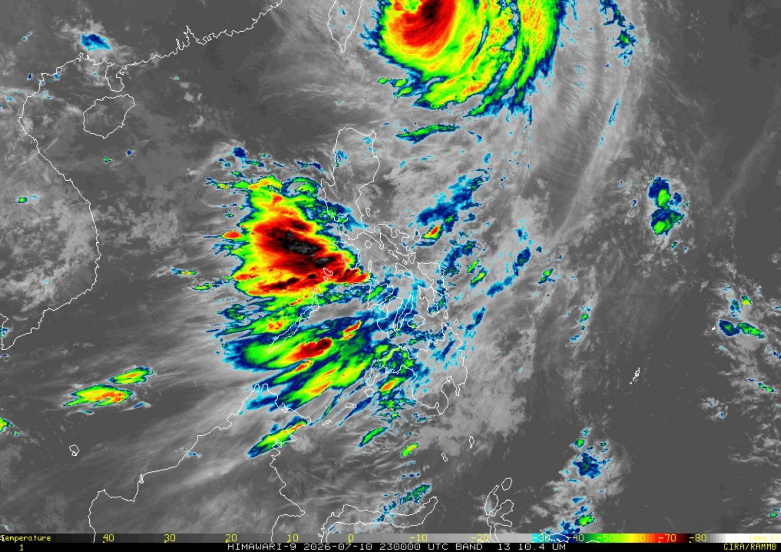
Typhoon Inday Nears PAR Exit; Signal No. 2 Now Limited to Itbayat
Typhoon Inday (international name: Bavi) is nearing its exit from the Philippine Area of Responsibility, heading northwest towards southern Japan. Tropical Cyclone Wind Signal No. 2 remains in effect solely for Itbayat, Batanes. The typhoon is expected to enhance the southwest monsoon, bringing strong gusts across various parts of the country.
MANILA, Philippines — Typhoon Inday (international name: Bavi) is nearing its exit from the Philippine Area of Responsibility (PAR) as it moves northwest towards southern Japan, the Philippine Atmospheric, Geophysical and Astronomical Services Administration (PAGASA) said early Saturday. In its 5 a.m. bulletin on Saturday, July 11, PAGASA said the center of Inday was estimated at 500 kilometers northeast of Itbayat, Batanes. It is packing maximum sustained winds of 140 kilometers per hour near the center and gustiness of up to 170 kph. The typhoon is moving northwestward at 20 kph. The following area remains under Tropical Cyclone Wind Signal No. 2: Under Signal No. 2, gale-force winds ranging from 62 to 88 kph may be experienced within 24 hours, posing a minor to moderate threat to life and property. Meanwhile, the following areas remain under Tropical Cyclone Wind Signal No. 1: Under Signal No. 1, strong winds ranging from 39 to 61 kph may be experienced within 36 hours, posing minimal to minor threats to life and property. PAGASA said the enhanced southwest monsoon and the outer circulation of Typhoon Inday will bring strong to gale-force gusts over most of the country Saturday. By Sunday, July 12, gusty conditions are expected over most of Luzon and most of Visayas, as well as Zamboanga del Norte, Misamis Occidental, Lanao del Norte, Camiguin and Davao Oriental. On Monday, July 13, strong to gale-force gusts may still affect most of Luzon, Panay Island and Negros Occidental. PAGASA said the enhanced southwest monsoon will continue to bring heavy rainfall over parts of the country. The weather bureau forecasts the following rainfall due to the southwest monsoon: Saturday, July 11 Sunday, July 12 Monday, July 13 PAGASA warned that rainfall may be higher in mountainous and elevated areas. Flooding and rain-induced landslides may occur, particularly in areas experiencing prolonged or intense rainfall. A gale warning remains in effect over the northern and eastern seaboards of Northern Luzon. Very rough to high seas are expected, with waves reaching up to 7 meters over the northern and eastern seaboards of Batanes. Waves of up to 6 meters are forecast over the remaining seaboards of Batanes, while waves of up to 5 meters are expected over the coastal waters of the Babuyan Islands and Cagayan. PAGASA advised all mariners to remain in port or, if already at sea, seek shelter or safe harbor until winds and waves subside. Small seacraft operators, including those using motorbancas, were also advised not to venture out over coastal waters experiencing rough to very rough seas. PAGASA said Inday is forecast to continue moving northwestward and may make landfall or pass close to the Sakishima Islands in southern Japan before exiting the Philippine Area of Responsibility this morning. The typhoon will then traverse the East China Sea before making landfall over the eastern coast of mainland China. Inday is forecast to remain a typhoon within the next 12 hours before weakening into a severe tropical storm after moving farther inland over mainland China.
多角的分析
台風インディのフィリピン海域からの離脱は、直接的な経済的被害のリスクを軽減するものの、南西モンスーンの強化による国内各地への大雨は、農業、特に米や野菜の収穫に影響を与える可能性がある。過去の事例では、モンスーンによる洪水が農作物の損失を招き、食料価格の上昇につながったことがある。これは、インフレ圧力に敏感なフィリピン経済にとって、追加的な負担となりうる。
台風インディの勢力低下とフィリピン海域からの離脱は、短期的な投資リスクを低減させる要因となる。しかし、南西モンスーンによる豪雨がインフラ、特に道路網や電力供給に一時的な支障をきたす可能性は否定できない。これは、物流コストの増加や、一部産業の操業停止につながりかねず、投資家はこれらのリスクを注視する必要がある。
台風インディによる暴風警報は、イタバヤット島住民の生活に直接的な影響を与える。また、南西モンスーンの強化による広範な大雨は、低地や河川沿いのコミュニティにおける洪水リスクを高める。特に、脆弱なインフラを持つ地方では、避難の必要性や家屋への被害、そしてそれに伴う生計への打撃が懸念される。過去の台風被害では、復旧に長期間を要するケースも少なくない。
台風インディの接近は、イタバヤット島住民にとっては直接的な脅威となる。シグナルNo.2の発令は、暴風雨への備えを促し、不要不急の外出を控えるよう求めるものである。また、南西モンスーンの強化による全国的な大雨は、他の地域の住民にとっても、外出や移動の際の注意を喚起する。特に、過去に洪水や土砂災害の経験がある地域では、住民の不安が増大する可能性がある。
背景・歴史的文脈
フィリピンは太平洋の「火山の輪」に位置し、台風銀座とも呼ばれる地域にあり、年間平均20個以上の台風が通過または接近する。これらの台風は、しばしば甚大な被害をもたらし、特に低所得者層やインフラの脆弱な地域に大きな影響を与える。過去には、2013年の台風ハイエン(ヨランダ)が約6,300人の死者を出し、数百万人に影響を与える壊滅的な被害をもたらした。気象庁(PAGASA)は、台風の進路予測と早期警報の発令を通じて、被害軽減に努めているが、地理的条件やインフラの限界から、完全な被害防止は困難な状況が続いている。
原文ソース
Philstar Nation