General articles are free for 24 hours after publish.
Tropical Depression Pilandok intensifies into tropical storm; monsoon rains batter northern Philippines
Tropical Depression Pilandok has intensified into a tropical storm, bringing heavy monsoon rains to four areas in northern Philippines. Scattered rain is also expected in other regions, including Metro Manila.
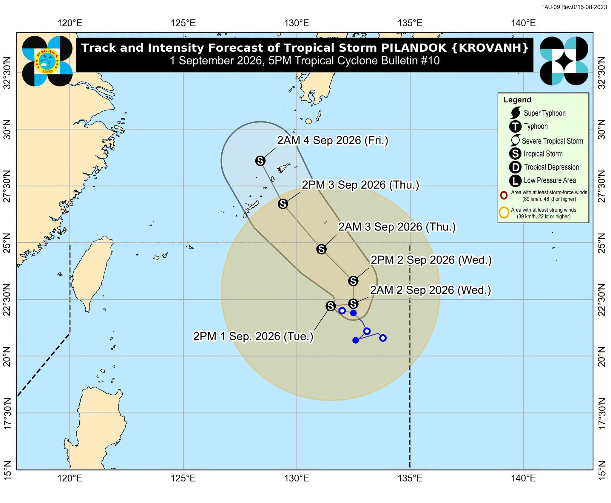
MANILA, Philippines – Tropical Depression Pilandok intensified into a tropical storm on Tuesday morning, September 1, while the southwest monsoon or habagat is still bringing moderate to heavy rain (50-100 millimeters) to Batanes, Ilocos Norte, Ilocos Sur, and Zambales. The Philippine Atmospheric, Geophysical, and Astronomical Services Administration’s (PAGASA) said Metro Manila, Cordillera Administrative Region, the rest of Ilocos Region, the rest of Cagayan Valley, the rest of Central Luzon, Cavite, Batangas, Rizal, Occidental Mindoro, Aklan, and Antique are seeing scattered rain and thunderstorms on Tuesday afternoon, while the rest of Luzon and Visayas can expect isolated rain showers or thunderstorms. Below is PAGASA’s latest heavy rainfall outlook due to the southwest monsoon: Tuesday afternoon, September 1, to Wednesday afternoon, September 2: Moderate to heavy rain (50-100 mm): Batanes, Ilocos Norte, Ilocos Sur, and Zambales. Wednesday afternoon, September 2, to Thursday afternoon, September 3: Moderate to heavy rain (50-100 mm): Ilocos Norte, Ilocos Sur, La Union, Pangasinan, Abra, Benguet, Zambales, Bataan, and Occidental Mindoro Thursday afternoon, September 3, to Friday afternoon, September 4: Heavy to intense rain (100-200 mm): Occidental Mindoro Moderate to heavy rain (50-100 mm): Zambales, Bataan, Pampanga, Cavite, Batangas, Oriental Mindoro, and Antique These areas should still watch out for floods and landslides. The southwest monsoon is also bringing strong to gale-force gusts, especially in coastal and upland areas exposed to winds, over most of Luzon and Visayas, Zamboanga del Norte, Misamis Occidental, Lanao del Norte, Misamis Oriental, Camiguin, Dinagat Islands, Davao Occidental, and Davao Oriental from Tuesday until Thursday. Moderate to very rough seas persist in the following areas: Up to very rough seas (travel is risky for all vessels) Western seaboards of Batanes and Babuyan Islands; the seaboard of Ilocos Norte — waves up to 5 meters high Seaboards of Ilocos Sur and northern La Union; the western seaboard of Pangasinan; the northern seaboard of Babuyan Islands; the remaining seaboard of Batanes — waves up to 4.5 meters high Up to rough seas (small vessels should not venture out to sea) Seaboard of Zambales — waves up to 4 meters high Seaboard of Lubang Islands; the western and southern seaboards of Bataan; the western seaboards of Cavite and Batangas — waves up to 3.5 meters high Remaining seaboard of Babuyan Islands; the western seaboards of northern Occidental Mindoro, Calamian Islands, and northern Palawan; the northern and western seaboard of Kalayaan Islands — waves up to 3 meters high Up to moderate seas (small vessels should take precautionary measures or avoid sailing, if possible) Seaboard of Isabela; western seaboard of central Palawan; the eastern seaboard of Davao Oriental; the remaining seaboards of Kalayaan Islands, Pangasinan, and La Union; the northern seaboard of Calamian Islands; the remaining western seaboard of Occidental Mindoro — waves up to 2.5 meters high Seaboards of mainland Cagayan, northern Aurora, Romblon, Cuyo Islands, Antique, Surigao del Sur, and Davao Occidental; the western seaboard of Burias Island; the southern seaboards of Quezon, Marinduque, Oriental Mindoro, Iloilo, and Guimaras; the southwestern seaboard of Negros Occidental; the remaining western seaboard of mainland Palawan; the remaining seaboards of Occidental Mindoro and Davao Oriental — waves up to 2 meters high PAGASA Weather Specialist Benison Estareja also said haze is affecting the western portions of Visayas, Mimaropa, and Mindanao due to forest fires from Kalimantan, Indonesia. Tropical Storm Pilandok (international name Krovanh) was last located 1,015 km east of extreme Northern Luzon, moving northwestward at 10 km/h, with maximum sustained winds of 65 kilometers per hour and gustiness of up to 80 km/h. It still has no effect on the country. With its current track, PAGASA said Pilandok may exit the Philippine Area of Responsibility (PAR) by late Wednesday or early Thursday. It will remain over the northern Philippine Sea as a tropical storm before approaching Okinawa, Japan. Aside from Pilandok, PAGASA is also monitoring Tropical Storm Saudel (formerly Obet) and a low pressure area outside PAR. The other tropical depression weakened into an LPA and has since dissipated. Saudel was located 685 km west of Calayan, Cagayan, moving east northeastward at 30 km/h, with winds of 65 km/h and gustiness of up to 80 km/h. Meanwhile, the LPA located 3,010 km east of southeastern Luzon still has a “medium” chance of developing into a tropical depression in the next 24 hours. Estareja said two to three tropical cyclones may develop within or enter PAR in September. – Rappler.com
Original source
Rappler Philippines