Tropical Depression Luis Makes Landfall in Isabela, Threatening Luzon with Heavy Rains and Landslides
Environment
2026年8月3日
4
Rappler Philippines

General articles are free for 24 hours after publish.

Tropical Depression Luis Makes Landfall in Isabela, Threatening Luzon with Heavy Rains and Landslides

Share
AI Summary

Tropical Depression Luis made landfall in Isabela province on Monday afternoon, bringing moderate to torrential rain to parts of Luzon. Authorities are on alert for floods and landslides, with the southwest monsoon expected to further intensify rainfall.

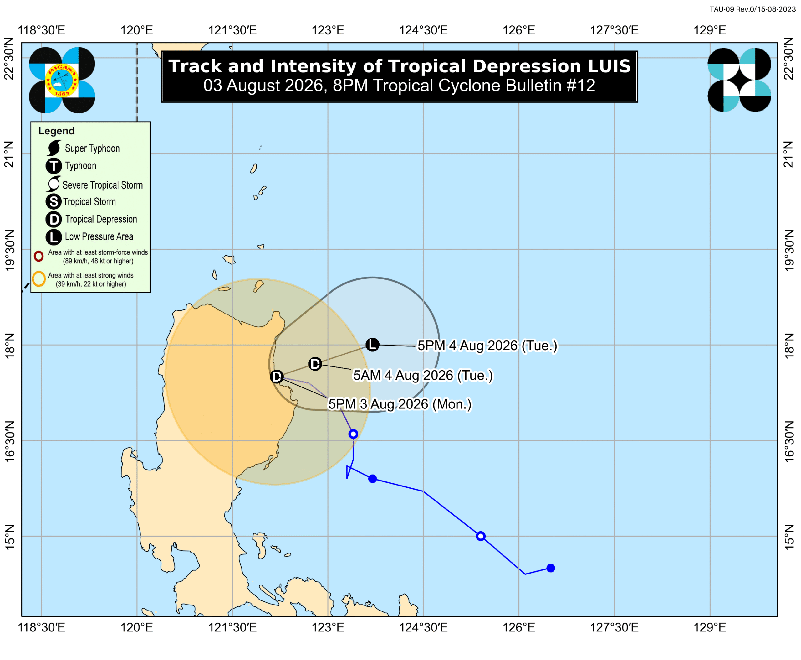
MANILA, Philippines – Tropical Depression Luis made landfall in Maconacon, Isabela, at 5:30 pm on Monday, August 3, still unleashing moderate to torrential rain in portions of Luzon. As of 7 pm on Monday, Luis was still in the vicinity of Maconacon. The tropical depression is moving west northwest at 20 kilometers per hour, with maximum sustained winds of 45 km/h and gustiness of up to 75 km/h. Following its landfall, Luis may begin turning east northeast, or away from the landmass of Luzon and towards the Philippine Sea. But the Philippine Atmospheric, Geophysical, and Astronomical Services Administration (PAGASA) reiterated in its 8 pm bulletin on Monday that the track of the tropical depression remains “highly uncertain” and can still change. PAGASA’s most recent rainfall advisory, issued at 5 pm on Monday, shows moderate to torrential rain from Luis continuing to hit parts of Luzon. Affected areas must stay on alert for floods and landslides. Monday afternoon, August 3, to Tuesday afternoon, August 4 Intense to torrential rain (above 200 millimeters): Pangasinan Heavy to intense rain (100-200 mm): La Union, Benguet, Tarlac, Zambales, Bataan Moderate to heavy rain (50-100 mm): Ilocos Sur, Ifugao, Mountain Province, Nueva Vizcaya, Quirino, Nueva Ecija, Aurora, Bulacan, Isabela, Pampanga, Metro Manila, Cavite, Batangas Tuesday afternoon, August 4, to Wednesday afternoon, August 5 Heavy to intense rain (100-200 mm): La Union, Pangasinan, Benguet, Tarlac, Zambales, Bataan Moderate to heavy rain (50-100 mm): Ilocos Sur, Nueva Vizcaya, Aurora, Nueva Ecija, Bulacan, Pampanga The southwest monsoon or habagat, already causing scattered rain and thunderstorms in Western Visayas, Negros Occidental, and Palawan on Monday evening, is also seen to trigger significant rainfall starting Tuesday, August 4. Heavy to intense rain (100-200 mm): Occidental Mindoro Moderate to heavy rain (50-100 mm): Metro Manila, Cavite, Batangas, Laguna, Rizal, Antique Wednesday afternoon, August 5, to Thursday afternoon, August 6 Moderate to heavy rain (50-100 mm): La Union, Pangasinan, Benguet, Zambales, Bataan, Cavite, Batangas, Occidental Mindoro, Antique Meanwhile, fewer areas remain under Signal No. 1 as of 8 pm on Monday. This means they are still seeing strong winds from Luis: central and eastern parts of Cagayan (Enrile, Tuguegarao City, Peñablanca, Piat, Santo Niño, Camalaniugan, Tuao, Lal-lo, Gonzaga, Alcala, Amulung, Santa Teresita, Baggao, Buguey, Solana, Rizal, Santa Ana, Gattaran, Iguig, Lasam, Aparri, Ballesteros, Abulug, Allacapan, Pamplona) including Babuyan Islands (Camiguin Island, Fuga Island, Didicas Island) Isabela eastern and southern parts of Apayao (Flora, Santa Marcela, Conner, Pudtol, Luna) eastern part of Kalinga (Tabuk City, Tanudan, Pinukpuk, Rizal) eastern part of Mountain Province (Paracelis, Natonin) eastern part of Ifugao (Aguinaldo, Alfonso Lista) The southwest monsoon and Luis’ periphery or outer bands are also bringing strong to gale-force gusts to these areas: Monday, August 3, and Tuesday, August 4 most of Luzon, most of Visayas, Zamboanga del Norte, Lanao del Norte, Misamis Occidental, Camiguin, Surigao del Norte, Dinagat Islands, Sarangani, Davao Occidental, Davao Oriental Wednesday, August 5 most of the country In the next 24 hours, conditions in certain seaboards will remain dangerous, particularly for small vessels. Up to rough seas (small vessels should not venture out to sea) Western seaboard of Pangasinan – waves up to 3 meters high Up to moderate seas (small vessels should take precautionary measures or avoid sailing, if possible) Seaboards of Isabela and Zambales; northern and eastern seaboards of Polillo Islands; northern seaboard of Camarines Norte; eastern seaboard of Davao Oriental; northeastern seaboard of Aurora – waves up to 2.5 meters high Seaboards of Batanes, Cagayan including Babuyan Islands, Ilocos Norte, Ilocos Sur, La Union, Surigao del Sur, and Davao Occidental; western seaboards of Bataan, Cavite, Batangas, Occidental Mindoro including Lubang Islands, and Calamian Islands; northern seaboard of Camarines Sur; northern and eastern seaboards of Catanduanes and Northern Samar; eastern seaboards of Albay, Sorsogon, Eastern Samar, Dinagat Islands, and Siargao-Bucas Grande Islands; southern seaboard of Davao Oriental; remaining seaboards of Pangasinan – waves up to 2 meters high Luis is now likely to weaken into a remnant low by Tuesday, a day earlier than initially predicted. After this downgrade, it will be fully absorbed into the circulation of the tropical cyclone with the international name Dolphin, which is currently a typhoon outside the Philippine Area of Responsibility (PAR). The typhoon was located 2,610 kilometers east northeast of extreme Northern Luzon as of 3 pm on Monday, moving west northwest at 25 km/h. Its maximum sustained winds slightly decreased from 155 km/h to 150 km/h in the afternoon, while its gustiness eased a bit from 190 km/h to 185 km/h. PAGASA is not ruling out the possibility of Dolphin entering PAR. The typhoon is not expected to have a direct impact on any part of the country, but it will enhance the southwest monsoon. Luis is the Philippines’ 12th tropical cyclone for 2026, and the first for August. PAGASA earlier said two to four tropical cyclones could develop within or enter PAR during the month. – Rappler.com

0

Original source

Rappler Philippines

原文を読む