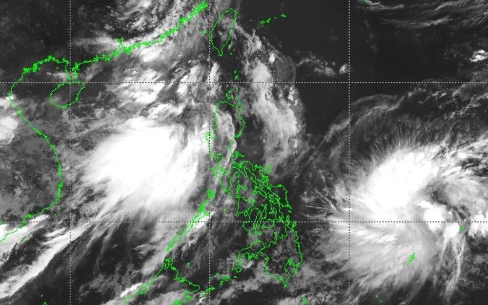
Tropical Cyclone 'Josie' Enters PAR, Weakens to Depression
Tropical cyclone 'Josie' has entered the Philippine Area of Responsibility (PAR) but has weakened into a tropical depression, with minimal direct impact expected. However, strong gusts from the southwest monsoon and rough seas are anticipated.
MANILA, Philippines — Tropical cyclone Josie (international name: Haishen) has entered the Philippine area of responsibility but has weakened into a tropical depression and is less likely to directly affect the country, PAGASA reported Tuesday, July 14. No tropical cyclone wind signal is currently raised. As of 8 a.m., the state weather bureau said Josie was being monitored inside PAR as a tropical depression. In its 5 a.m. bulletin, when Josie was still classified as a tropical storm, PAGASA placed its center at 1,085 kilometers east of Eastern Visayas. It had maximum sustained winds of 65 kilometers per hour near the center and gusts of up to 80 kph. Josie was moving northwestward at 25 kph, with strong to gale-force winds extending outward up to 480 kilometers from the center. PAGASA said Josie is less likely to directly affect the country's weather throughout the forecast period. Forecast track. The cyclone is forecast to move generally northward until Wednesday, July 15, before turning northeastward. It is forecast to exit PAR by Tuesday night or Wednesday morning. PAGASA also said Josie may further weaken into a low pressure area by Wednesday due to an unfavorable environment. Habagat hazards. While Josie is not expected to directly affect the country, the southwest monsoon is forecast to bring strong to gale-force gusts over several areas in Luzon, especially coastal and upland areas exposed to winds. On Tuesday, these gusts may affect Ilocos Region, Cordillera Administrative Region, Cagayan Valley, Central Luzon, Cavite, Batangas and Occidental Mindoro. On Wednesday, July 15, they may affect Ilocos Region, Abra, Apayao, Zambales, Bataan, Batanes and Babuyan Islands. By Thursday, July 16, strong to gale-force gusts may still affect Ilocos Region, Abra, Apayao, Batanes and Babuyan Islands. Rough seas. PAGASA said rough seas of up to 3 meters may affect the western seaboards of Babuyan Islands and Pangasinan, as well as the seaboards of Ilocos Norte, Ilocos Sur and La Union. Small seacraft, including motorbancas, are advised not to venture out to sea under these conditions, especially if operators are inexperienced or vessels are ill-equipped. Moderate to rough seas may also affect the remaining seaboard of Pangasinan, the seaboards of Batanes and Zambales, and the western seaboards of Bataan, Batangas and Occidental Mindoro, including Lubang Islands. Similar sea conditions may affect the remaining seaboards of Babuyan Islands, the southern seaboard of Bataan, and the northern seaboards of mainland Cagayan, Calamian Islands and Kalayaan Islands. PAGASA is also monitoring another low pressure area outside PAR. As of 8 a.m., the LPA had a medium chance of developing into a tropical depression within the next 24 hours. The public is advised to monitor updates from PAGASA.
多角的分析
熱帯低気圧「ジョシー」のフィリピンへの直接的な影響は限定的と見られるものの、南西モンスーンによる強風や荒れた海況は、漁業や沿岸部の小規模な商業活動に一時的な支障をきたす可能性がある。特に、漁船の出港制限は、地域経済の生計を支える漁業従事者にとって直接的な収入減に繋がりうる。また、インフラへの被害は軽微と予想されるが、突風による一時的な停電や通信障害などは、経済活動の円滑な進行を妨げる要因となりうる。フィリピン経済は、自然災害の影響を受けやすい構造にあるため、こうした小規模な気象現象であっても、積み重なれば経済成長の足かせとなる。
今回の熱帯低気圧「ジョシー」の進路と勢力低下は、フィリピン経済全体への直接的な投資リスクを大きく軽減させる。特に、インフラや大規模商業施設への物理的な被害の懸念が薄まるため、短期的な市場の動揺は限定的だろう。しかし、沿岸部や漁業関連産業への影響は無視できない。投資家は、こうした局地的な影響を注視し、サプライチェーンへの潜在的な遅延や、地域経済の回復力を見極める必要がある。フィリピンは台風銀座とも呼ばれるほど気象災害が多い国であり、投資判断においては、こうしたリスクを織り込んだ長期的な視点が不可欠である。
熱帯低気圧「ジョシー」の直接的な影響は限定的とされているものの、南西モンスーン(ハバガット)による影響は、特にルソン島沿岸部や高台に住む住民にとって、依然として不安材料となる。強風や荒れた海況は、日々の生活、特に漁業に依存するコミュニティの生計を直接脅かす。例えば、イロコス地方の沿岸部で漁業を営む人々は、数日間の出漁制限により収入が途絶える可能性がある。また、予期せぬ突風は、移動手段に影響を与えたり、屋外での活動を困難にしたりするなど、日常生活に支障をきたす。PAGASAからの情報収集が重要となるが、地方では情報伝達の遅れや、インフラの脆弱性から、迅速な対応が難しい場合もある。
今回の熱帯低気圧「ジョシー」は、フィリピンに直接的な大きな被害をもたらす可能性は低いと報じられています。しかし、南西モンスーンの影響で、ルソン島の一部地域では強風や荒れた海が予想されています。これは、沿岸部で暮らす人々、特に漁師さんたちにとっては、仕事ができなくなることを意味します。例えば、イロコス地方の漁師たちは、海が荒れて出漁できなければ、その日の収入がなくなってしまいます。また、強風は、移動手段であるモーターバンカーの運航にも影響を与え、交通網にも混乱が生じる可能性があります。私たちは、PAGASAの最新情報を確認し、安全に注意して過ごす必要があります。幸い、今回は大きな被害はなさそうですが、台風シーズンのフィリピンでは、常に備えが必要です。
背景・歴史的文脈
フィリピンは太平洋の「台風銀座」に位置し、年間平均20個以上の台風が接近または上陸する。熱帯低気圧の監視・警報システムは、国民の生命と財産を守る上で極めて重要である。PAGASA(フィリピン大気地球物理学天文庁)は、熱帯低気圧の進路予測や強度変化を日々発表し、警報レベルの発令や避難指示の根拠となる。近年の気候変動の影響も指摘されており、より強力で予測困難な気象現象への対応が求められている。また、南シナ海情勢の複雑化に伴い、気象情報が災害対応だけでなく、地域的な安全保障の文脈で注目されることもある。
原文ソース
Philstar Nation