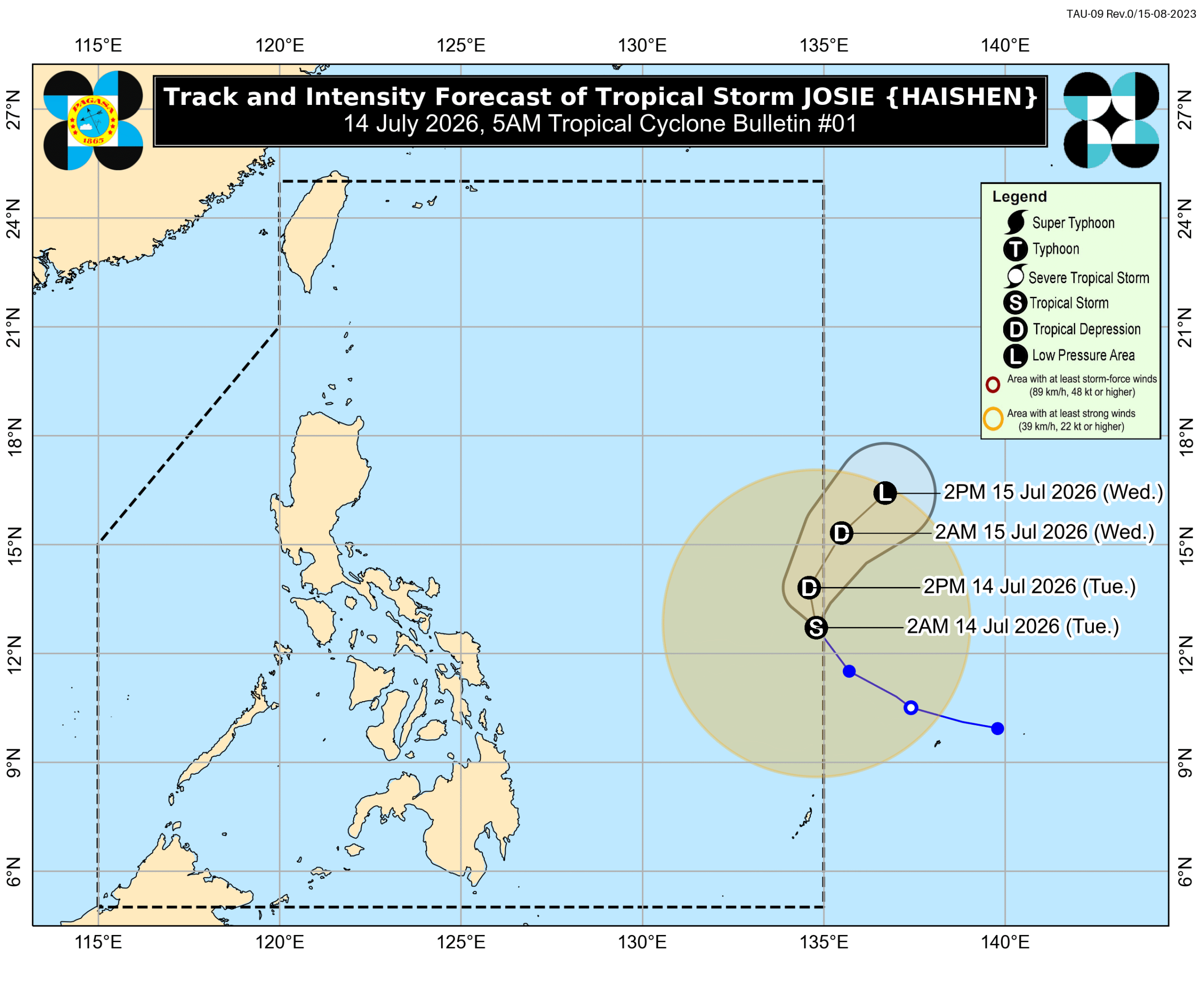
Tropical Storm Josie briefly enters PAR
Tropical Depression Haishen intensified into Tropical Storm Josie and entered the Philippine Area of Responsibility (PAR) briefly before expected to weaken. Southwest monsoon will bring scattered rains and strong gusts to some areas.
MANILA, Philippines – Tropical Depression Haishen intensified into a tropical storm at 8 pm on Monday, July 13, then entered the Philippine Area of Responsibility (PAR) at 12:30 am on Tuesday, July 14. The tropical storm’s international name is Haishen, a name contributed by China which refers to the god of the sea. Following its entry into PAR, it was given the local name Josie. It is the Philippines’ 10th tropical cyclone for 2026, and the third for July. In a bulletin issued at 5 am on Tuesday, the Philippine Atmospheric, Geophysical, and Astronomical Services Administration (PAGASA) said Josie was located 1,085 kilometers east of Eastern Visayas as of 4 am. The tropical storm is moving northwest at 25 kilometers per hour, with maximum sustained winds of 65 km/h and gustiness of up to 80 km/h. There are no rainfall or wind warnings due to Josie, which will only stay near the PAR eastern boundary. It could already leave PAR on Tuesday evening or Wednesday morning, July 15. Josie may also be downgraded back to a tropical depression in the next 12 hours, and further weaken into a low pressure area by Wednesday. Meanwhile, rainfall from the southwest monsoon or habagat is expected to be confined to the Ilocos Region on Tuesday. PAGASA said the provinces of Ilocos Norte, Ilocos Sur, and La Union will still have scattered rain and thunderstorms due to the southwest monsoon during the day. Flash floods and landslides remain possible. The rest of the country will see generally fair weather, with just isolated rain caused by localized thunderstorms. The southwest monsoon is also bringing strong to gale-force gusts to these areas: Tuesday, July 14 Ilocos Region, Cordillera Administrative Region, Cagayan Valley, Central Luzon, Cavite, Batangas, Occidental Mindoro Wednesday, July 15 Ilocos Region, Abra, Apayao, Zambales, Bataan, Batanes, Babuyan Islands Thursday, July 16 Ilocos Region, Abra, Apayao, Batanes, Babuyan Islands In addition, moderate to rough seas are expected in several seaboards on Tuesday, still due to the southwest monsoon. Up to rough seas (small vessels should not venture out to sea) Western seaboards of Babuyan Islands and Pangasinan; seaboards of Ilocos Norte, Ilocos Sur, and La Union – waves up to 3 meters high Up to moderate to rough seas (small vessels should take precautionary measures or avoid sailing, if possible) Remaining seaboard of Pangasinan; seaboards of Batanes and Zambales; western seaboards of Bataan, Batangas, and Occidental Mindoro including Lubang Islands – waves up to 2.5 meters high Remaining seaboards of Babuyan Islands; southern seaboard of Bataan; northern seaboards of mainland Cagayan, Calamian Islands, and Kalayaan Islands – waves up to 2 meters high – Rappler.com
多角的分析
熱帯低気圧「ジョシー」はフィリピン海域に短時間滞在するものの、直接的な大きな被害をもたらす可能性は低い。しかし、南西モンスーンによるイロコス地方での散発的な雨や雷雨は、農業活動に一時的な影響を与える可能性がある。特に、収穫期に近い農作物や、インフラが脆弱な地域では、鉄砲水や地滑りが農地や物流網に損害を与えるリスクが考えられる。長期的な経済への影響は限定的と見られるが、局地的な被害への備えは重要である。
今回の熱帯低気圧「ジョシー」の接近は、フィリピン経済全体への影響は軽微と見られる。直接的なインフラ被害や広範囲な事業停止のリスクは低い。しかし、イロコス地方など一部地域での南西モンスーンによる影響は、短期的な物流の遅延や、小規模農産物サプライチェーンへの影響をもたらす可能性がある。投資家としては、この種の気象イベントが日常的に発生するフィリピンにおいて、サプライチェーンのレジリエンス(強靭性)を評価する上で、より広範な気象リスク管理体制を持つ企業や、インフラの強固な地域に投資する戦略が引き続き重要となる。
熱帯低気圧「ジョシー」の接近は、フィリピンの広範な地域で直接的な大きな被害をもたらす可能性は低いものの、南西モンスーンの影響を受けるイロコス地方の住民にとっては、鉄砲水や地滑りのリスクが懸念される。これらの災害は、特にインフラが未整備な農村部や沿岸部で生活基盤を脅かし、避難生活を強いられる人々を生む可能性がある。また、海上での注意喚起は、漁業に依存するコミュニティの生計に影響を与える。フィリピンは年間を通じて多くの熱帯低気圧に見舞われるため、こうした気象現象への適応と、地域社会の防災能力向上が継続的な課題となる。
今回、熱帯低気圧「ジョシー」はフィリピン海域を短時間で通過するため、多くの国民は直接的な影響をあまり感じないだろう。しかし、イロコス地方では、南西モンスーンによる雨で、突然の洪水や土砂崩れが起こりうるため、注意が必要だ。特に、川の近くや山間部に住む人々は、PAGASAからの最新情報を常に確認し、避難の準備をしておくことが大切だ。また、沿岸部や離島では、船での移動に影響が出る可能性があり、漁業関係者や旅行者は気象情報を注視する必要がある。
背景・歴史的文脈
フィリピンは、太平洋の「火山の輪」と「台風銀座」に位置するため、年間を通じて地震や台風、火山活動などの自然災害に見舞われやすい国である。特に熱帯低気圧は、フィリピンの気象庁(PAGASA)が管理する「フィリピン海域(PAR)」に入ると、その進路や強度によって広範囲に影響を及ぼす。今回、熱帯低気圧「ヘイシェン」が「ジョシー」としてPARに入ったことは、フィリピンにとって年間の熱帯低気圧シーズンが進行中であることを示している。南西モンスーン(ハバガット)は、雨季にフィリピンに湿った空気を運び込み、しばしば広範囲にわたる豪雨や洪水、地滑りを引き起こす。これらの自然現象は、フィリピンの社会経済活動、特に農業やインフラに継続的な課題を投げかけている。
原文ソース
Rappler Philippines